Monthly Summary January 2016 – Rainiest Jan 27 since 1896 – Low Snow
Close to normal temperatures but slightly drier January hides near record day rainfall and low snowpack.
Happy Groundhog Day! 🙂
The totals and averages and records in January 2016 were not hugely notable. The combination of the weakening of the “blob” and the influence of El Niño seem to have combined to generate a fairly normal regime. We were very close to normal temperature wise, just slightly above. And we received about 75% of our normal rainfall.
The rain did provide a notable record on January 27th when we received 74mm of rain at the Environment Canada station (yes it actually measured it!). This is second only to a rainfall of 84mm at the old Beaver Creek station in 1896! So that is pretty cool.
It is worth noting that after half of the month being rain-measurement-less the Environment Canada station finally kicked into gear half way through the month. I am hoping that means someone noticed the problem and fixed it. Unfortunately, both my station, and the Maquinna station have had rain measurement problems this month (mine was due to a plugged bucket.. now fixed). So the only station I got a full month of rain data from was the Alberni Elementary station. However, I called up Nick Vanderest who has a station near Maquinna and have used his numbers in place of Maquinna so that I at least have two. Thanks Nick!
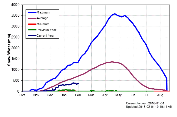
The other notable thing about the month is the snowpack, or lack thereof. Obviously it seems like we have a fair amount of snow on the mountain compared to last year, however, we must remember that last year was near zero *all year*. It was a worst case scenario. We remain below average for this time of year. There is more information from the River Forecast centre further down this post.
El Niño update
The latest El Niño forecast was released January 14th. Here is the full forecast.
A strong El Niño is expected to gradually weaken through spring 2016, and to transition to ENSO-neutral during late spring or early summer.
A strong El Niño continued during December, with well above-average sea surface temperatures (SSTs) across the central and eastern equatorial Pacific Ocean (Fig. 1). All weekly Niño indices decreased slightly from the previous month (Fig. 2). The subsurface temperatures in the central and eastern Pacific, while still well above average, weakened (Fig. 3) due to an upwelling equatorial oceanic Kelvin wave (Fig. 4). Significant low-level westerly wind anomalies and upper-level easterly wind anomalies continued over much of the tropical Pacific. During the last week, another westerly wind burst occurred in the east-central Pacific. The traditional and equatorial Southern Oscillation Index (SOI) values remained strongly negative. Also, convection remained strong over the central and east-central tropical Pacific, and suppressed over Indonesia (Fig. 5). Collectively, these atmospheric and oceanic anomalies reflect the continuation of a strong El Niño episode.
Most models indicate that a strong El Niño will weaken with a transition to ENSO-neutral during the late spring or early summer (Fig. 6). The forecasters are in agreement with the model consensus, though the exact timing of the transition is difficult to predict. A strong El Niño is expected to gradually weaken through spring 2016, and to transition to ENSO-neutral during late spring or early summer.
El Niño has already produced significant global impacts and is expected to affect temperature and precipitation patterns across the United States during the upcoming months (the 3-month seasonal outlook will be updated on Thursday January 21st). The seasonal outlooks for January – March indicate an increased likelihood of above-median precipitation across the southern tier of the United States, and below-median precipitation over the northern tier of the United States. Above-average temperatures are favored in the West and northern half of the country with below-average temperatures favored in the southern Plains and along the Gulf Coast.
Well Below Average Snowpack Seems Huge
When last year (green line below) was zero, anything more than that seems like a ton. But as you can see we are still well below average and really have not received much snow input since December.
The River Forecast Centre has this to say about the snowpack this season. They will release an update on February 9th.
Fall and early-winter has seen the dissipation of warm water in the northern Pacific Ocean (i.e. the “Blob”) which has been present over the past two winter seasons, and was likely the key driver in the very warm winters and extremely low snow packs that occurred in southern BC in 2014-15.
By early January, nearly half of the annual BC snowpack has typically accumulated. At this early stage in the season, there is limited indication that any regions of the province are developing increased seasonal flood risk.
Outlooks — Stable with periodic precipitation. Little chance of ‘white’.
Here are the 16-day GEPS consensus graphs from SpotX. Not much rain in the next couple weeks (150mm). Temperatures look to be moderating. Note the wind possibility this weekend.


Three-Month Forecasts
The heat in Canada, especially northern Canada remains impressive. More than 3ºC above normal in some parts of the North! Remember that this is an ensemble, so it is a collection of models. The forecast remains steady for well above normal temperatures on average for the whole country.
Here is last month’s picture for the previous three month period.

Here is the Precipitation Forecast. We remain at or below normal in our region. El Niño’s classic north/south tier of North America pattern remains pretty clear here.
Last month’s forecast for the previous 3 month period.

Temp/Precip Spring, Summer, Fall and/or Winter forecast from current and last month runs (generally only 1 of 2 seasons are within the forecasts).


And finally the Sea Surface Temperature anomaly for the next 3 months. The Pacific heat near North America is slated to weaken a little as is El Niño but it is still significant.


That’s it!
Monthly Timelapse Video
Daily records set this month at the Airport (and compared to other stations* for “All Time”)
One new Airport high temp, two rain, no all time records (but close!).
- January 26 rain 22.2 mm : #1 is 63.2 mm in 1992 at Robertson Creek.
- January 27 rain 74.0 mm : #1 is 86.4 mm in 1896 at Beaver Creek. (2016 ranks #2, 1987 RC 71mm, 1931 PA 71mm)
- January 28 high 11.1º C : #1 is 15.6º C in 1940 at Port Alberni City.
*Short Term (since 1995) Airport Records are compared to the 30+ year weather stations of record since 1895 at Beaver Creek, Port Alberni City and Robertson Creek.
January 2016 Minimum, Overall and High Daily Average Temps See last month’s and last January’s summary.
Alberniweather: 1.5º C, 2.8° C, 4.4º C
Alberni Elementary School : 1.6º C, 2.8º C, 4.6° C
Maquinna Elementary School: 1.2º C, 2.3º C, 3.8° C
Neptune Canada Station: 1.7º C, 3.0º C, 4.6° C
Overall City Average: 1.5º C, 2.7 C, 4.4º C
Environment Canada Airport: 0.3º C, 2.3° C, 4.1º C
1981-2010 EC Normal (Robertson Creek): -0.3º C, 2.0º C, 4.3° C
Precipitation for January 2016:
Alberniweather: NA (rain gauge blocked part of month)
AES: 258.8 mm
MAQ: 251.8 mm (Maquinna down, using Nick who lives close by)
NEP: NA (not measured)
Overall City Average: 255.3 mm
EC: (Not Relevant 14 Days Missing Data!)
1981-2010 Env Canada Normal (Robertson Creek): 339.5 mm
City Stations Temperature Difference from normal:
1.8° C, 0.7º C, 0.1º C
Official (Airport) Temperature Difference from normal:
0.6º C, -0.3º C, -0.2º C
City Stations Precipitation difference normal:
-84.2 mm (75.2% of normal)
Official (Airport) Precipitation difference from normal:
NA
Days of Precipitation for January 2016*
>= 0.2 mm: Normal: 21.6 : This Month: 23
>= 5 mm: Normal: 13.3 : This Month: 13
>= 10 mm: Normal: 10.3 : This Month: 8
>= 25 mm: Normal: 4.9 : This Month: 4
*Denotes incomplete official Airport station data so using data from Alberni Elementary.
Comparison to recent months of January at Alberniweather (unless specified)
- 2015: See the January 2015 Summary Here (No Snow) .
- 2014: See the January 2014 Summary Here (DRIEST OCTOBER-JANUARY EVER ).
- 2013: Similar temperature but driver 2013.
- 2012: Similar temperature but wetter 2012.
- 2011: Similar temperature but drier 2011.
- 2010: Much warmer and rainier in 2010.
- 2009: Warmer temperature and much more rainfall 2016.
- 2008: Warmer this year (2016) same rainfall.
- 2007: Quite similar to this year.
- 2006: Much cooler 2016 and less rain.


