

Record set at Airport – 3rd Highest All Time
The storm yesterday produced one of the rainiest Christmas days in Port Alberni history. The Airport recorded the most rain ever in its history since 1994 for that day: 70.6mm. As I posted on Mastodon this morning:
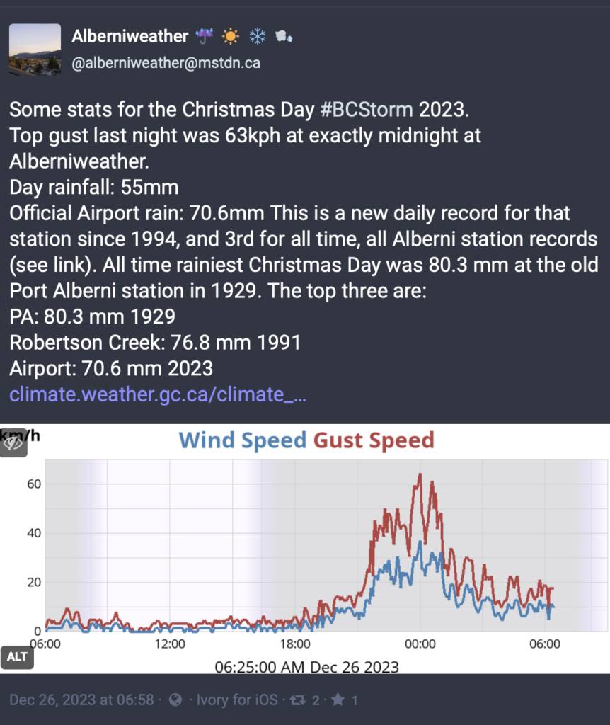
Only 1929 at Port Alberni City with 80.3 mm and 1991 at Robertson Creek with 76.8 mm featured measurements higher than yesterday. Side Note: The Somass “Port Alberni A” station measured 64mm on December 25, 1991.
We also got some strong winds. We saw two peaks in the wind, the highest at midnight with 64kph and another at 12:35PM at 61kph.
Rockfall closes Highway 4
Sometime in the early evening on Christmas Day a large boulder came down near the Cameron Lake Fire area, knocked a tree across the highway and planted itself, according to some pictures (credit Naani Thomas — Facebook) I’ve seen, in the ditch.

This led to a geotechnical assessment overnight and cleanup this morning. The road remains closed at this time but the latest update at 2PM expects reopening by 3PM. We’ll see if that is able to happen. Keep an eye on the DriveBC messages here for the latest.
More weather coming – Worst for Wednesday Night
The forecast last week promised a line of storms, and that’s holding true. We’re in for some more rain and wind. Here’s how it will unfold.
Tuesday Night/Wednesday morning – Short, not too bad.
Rain will start again tonight, landing on the West Coast of the Island and Port Alberni in the 7-10PM hour:

Thankfully this one looks light. It will move swiftly over the Island. There will be gusty winds but rain accumulation should only be around 10mm at most. Rain should end on the West Coast by 4AM Wednesday morning and a little later elsewhere.

Quick Follower – Wednesday Daytime Storm
There will only be a few hours break, if that. The next front moves onto the Island around 7AM. There will be strong winds with this one. The map below shows southeast winds off the West Coast up to 50knots (92kph).

Another bout of heavy wind will occur around 7PM on Wednesday with winds up to 80kph or so.
Rather than one large system, this front will deliver bands of potentially heavy rain across parts of the Island through Wednesday and Thursday. Some areas might get a lot of rain out of this and some much less. It will be difficult to predict. This is what the model has for the total 24hr accumulation from Wednesday 4AM to Thursday 4AM:


Port Alberni and the East Island looks to expect around 20-30mm on Wednesday. The West Coast might get up to 40mm. Expect about the same or a little less on Thursday.
More for Friday
It will dry out a little on Thursday night but a final system will come in on Friday afternoon and into Saturday with another 10mm or so. Thankfully, we’ll get a few days rest starting Saturday and into early next week. New Year’s Eve and Day look mostly dry. Maybe a scattered shower.
Stay safe out there!