
Category: Wind
-

There be a Storm brewin’.
Environment Canada has issued a Special Weather statement in preparation for a possible rain and wind storm Sunday night and into Monday. Here is their bulletin: Issued at 2018-11-24 23:54 UTC by Environment Canada: Special weather statement issued for: East Vancouver Island, B.C. (081300) West Vancouver Island, B.C. (081400) Inland Vancouver Island, B.C. (081500) Current details: Strong…
-
Fall Weather is Here – Rain Starting Tuesday night – Possible Stormy Sunday
Showers should have begun or will begin very shortly this evening as our pattern shifts completely from the big safe zone of high pressure that gave us two weeks of sunshine, to a more normal storm track that is going to give us some rain, and maybe some wind too. There are pockets of showers…
-

Red Sky Thursday morning, sailors warning. But first day of fall Sunday might feel summery.
The final days of summer (Fall Equinox is at 6:54PM PDT Saturday Sept 22) are going to be wet and blustery. The eastern sky is bright red this morning in Parksville as I wait for my bus to VIU. Like the old sailors rhyme says… this is a signal of stormy weather to come. Continue…
-

Hopefully the fog clears. Break day before Friday/Saturday rain
Well, where Tuesday had some unexpected sun, Wednesday went made up for it with a full day of rain. We will have a break now. It got quite cool overnight, 3.4ºC at Alberniweather so that has brought about some fog. Hopefully we will see it lift as it is only partly cloudy above. Unfortunately, the…
-

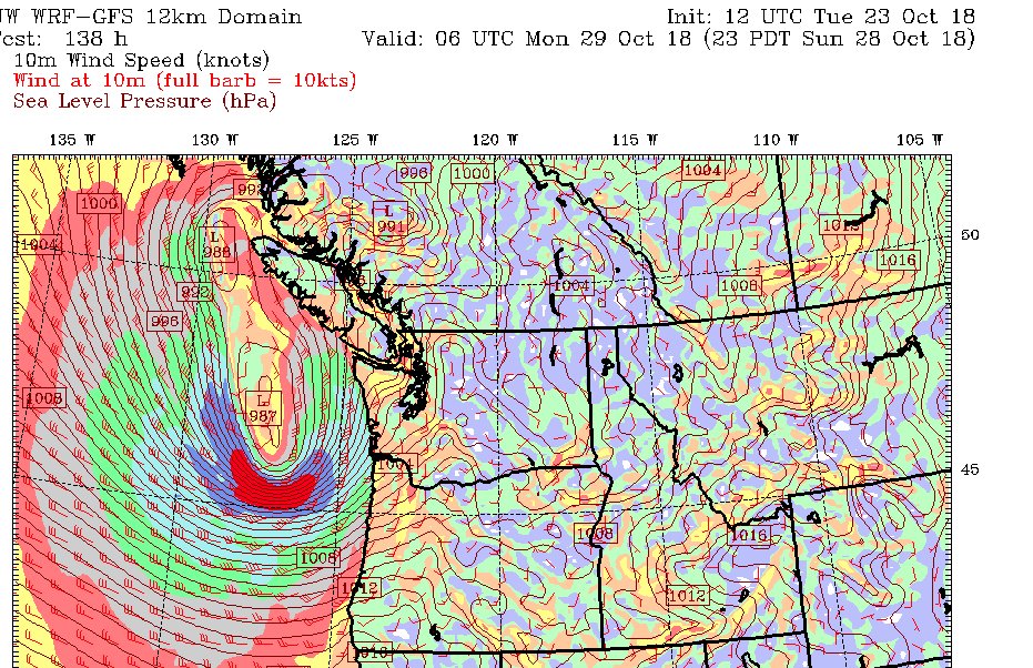
Wind Warnings up for West Island – Stormy Days ahead
I was waiting to see if Environment Canada would post a warning and indeed they did. It is currently only for the West Coast. Tofino and Ucluelet. Here’s the rundown on when to expect the rain and wind in Port Alberni.