
Author: Alberniweather
-

Rain Friday night. Break Saturday, then rain Sunday morning.
It is Groundhog day. And yes, the rain just keeps coming back. This weekend will be no different. It is going to rain overnight tonight as you can see below: However, it should dry out and maybe even clear a little Saturday morning. Rain will begin again on Saturday evening and overnight. Before clearing again…
-
Persistent showers through to Sunday but nothing crazy
A short post today: We will finish off the month of January and start the first few days of February wet. We are not expecting any huge downpours or anything, but the current weather pattern of showers, short breaks in the clouds, and more showers looks like it will continue through Friday with a final…
-

Update 7:30AM Saturday —- East Coast snow possible Saturday — Possible Flooding Storm Monday
Update 7:30AM Snowfall Warning issued for East side of the Island. EC just issued a snowfall warning from Comox down to Nanoose. Another 5cm is expected this morning. The drive BC cameras show plenty of snow on that side already. Here is the highway 4 junction at Coombs. Drive safely. I will have an update for…
-

Drivers: Cold and Sleet early Friday… Snowy and Stormy in store for Saturday
Now… back to the weather…. We are into a pretty unstable and cool pattern. Temperatures aren’t expected to get above 4ºC from today until Sunday. Showers should start Thursday evening in the 7PM hour (in grey below) with snow at higher elevations (in green). It will be short lived though and spotty. Beware: There is…
-
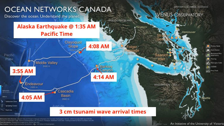
What happened, and what to learn, on the Jan 23 2018 Tsunami
Tsunami Siren Evacuation – What happened, for the record. Here’s a full rundown of what happened on Tuesday… a few things we learned… and a few things for next time. First, this is what the siren sounded like at 3:45AM after I had evacuated my family: https://twitter.com/alberniweather/status/955787063697145856