
Tsunami Siren Evacuation – What happened, for the record.
Here’s a full rundown of what happened on Tuesday… a few things we learned… and a few things for next time.
First, this is what the siren sounded like at 3:45AM after I had evacuated my family:
https://twitter.com/alberniweather/status/955787063697145856
The sirens and evacuation message sounded twice every 10 minutes. You can see the headlights of cars moving up the road in the video.
The warning message statement is “Tsunami Warning. Tsunami Warning. Please Evacuate to Higher Ground”
The system was activated at approximately 3:15AM PST, on January 23rd, 2018 by the City of Port Alberni in consultation with the Alberni Clayoquot Regional District (ACRD) Emergency Operations Centre and Emergency Management BC (EMBC).
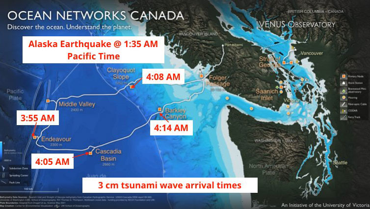
This was due to a 7.9M Earthquake in the Gulf of Alaska that occured at 1:32AM PST that resulted in a Tsunami Warning being issued by the US NOAA National Weather Service at 1:35AM PST for the West Coast of BC, SouthEast Alaska, South Alaska and the Alaska Peninsula, and the Aleutian Islands.
That initial NOAA Tsunami Warning was followed up by a Tsunami Warning from EMBC issued at 2:06AM PST for zones A, B, C, and D of the B.C. West Coast. Port Alberni is in Zone C, Outer West Coast of Vancouver Island from Cape Scott to Port Renfrew).
#tsunami warning for BC notification zones A, B, C & D. More information from Environment Canada: https://t.co/y28IfBkpdm pic.twitter.com/JJrBei92v5
— Emergency Info BC (@EmergencyInfoBC) January 23, 2018
A Tsunami Warning from EMBC means a “Flood Wave is Possible” and “Full Evacuation is Suggested” for affected areas.
Only Zone E, which is the Strait of Georgia, Gulf Islands, Greater Vancouver and Johnstone Strait were not included in the warning.
Just after that… if you happened to be listening to Bob Marley on 93.3 The Peak at 2:16AM… you would have heard this automated message:
At 2:26AM EMBC tweeted:
If you are in a #tsunami warning area, move out of the water, off the beach & away from harbors, marinas, breakwaters, bays & inlets. Follow instructions from your local emergency officials because they may have more detailed or specific information for your location.
— Emergency Info BC (@EmergencyInfoBC) January 23, 2018
Here is the Tsunami Inundation Zone Map you all hopefully are more familiar with now:

At 3:55AM, a 3cm (0.1ft) Tsunami registered on the outer most bottom pressure sensors in the Oceans Canada network off of Barclay Sound which has its base station in Port Alberni.

There is a great write up here on their blog:
http://www.oceannetworks.ca/data-alaska’s-magnitude-79-earthquake-and-tsunami
the Alaska earthquake generated a small tsunami detected by @Ocean_Networks sensors off Canada's westcoast #tsunami pic.twitter.com/MK0K0SLOi8
— Dr. Kate Moran (@katemoran) January 23, 2018
They even tweeted the raw data, nearly in real time that morning:
Alaska #tsunami just passed @Ocean_Networks bottom pressure station at Clayoquot Slope: 3-cm sea level drop; not big but there.https://t.co/b27CdUo3as pic.twitter.com/T6A8FT2SdT
— Martin Scherwath (@mscherwath) January 23, 2018
At 4:12AM PST the US NOAA Tsunami Warning Centre canceled their Tsunami Warning for most of the Coast, including BC. Tsunami wave heights were reported in that message of between 0.4ft (12cm, 0.12m) and 0.7ft (21cm, 0.21m) recorded in various locations in Alaska.
The City of Port Alberni ran the “All Clear” signal on the Tsunami Warning system at about 4:30AMPST
https://twitter.com/alberniweather/status/955780099541843968
The message is:
“All Clear, All Clear, Emergency Has Been Cancelled”
Interesting side note: A 4.5M earthquake occurred off of Port Hardy just 2 minutes after the large Alaska quake. Likely not a coincidence?
https://twitter.com/CANADAquakes/status/955736889717329920
Why was it so small?
It was a “Strike – Slip” horizontal earthquake, rather than a subduction, vertical, earthquake, so the displacement of water was much less. We were lucky, as Johanna Wagstaff, seismologist and meteorologist at CBC pointed out, had the earthquake hit just 90km to the west, it would have been in the subduction zone, and” we could have seen a massive tsunami”.
Unfortunately, we don’t know the size of tsunamis until the pass through one of our small network of sensors scattered around the edges of the ocean. So that’s why the warning was sounded, even though in the end, it was just a tiny wave. Better safe, than sorry.
Things to Learn
The most common question I heard during and after the event was:
“Where do I go?” and/or “Where is safe”?
Answer #1: If you are above the brown line, 20 metres elevation above sea level, you are considered safe from Tsunami. If you have an iPhone, you can even ask Siri “How High am I?”. When I do this for my home, Siri says I am at 31 metres… which is correct according to GPS and other sources.
Answer #2: If you need to evacuate and have nowhere else to go, the Echo Community Centre (4255 Wallace St) is opened first for evacuees. It was opened at around 4:20AM, but closed at 4:30AM after the warning was lifted. The AV Multiplex (3737 Roger St) may also be opened if needed. Both of these locations are accessible from anywhere in the Valley by following evacuation routes to above the Tsunami inundation zone and then following Johnston Road/Hwy 4, Redford, and/or 10th Avenue. Other recommended muster points are the Walmart/Canadian Tire Shopping Centre parking lots or the 10th and Redford Shopping centre areas.
There is no need to go “up the hump” (Alberni Summit) and in fact considering emergency services may be needed to come into the Valley in the event of a major Tsunami, it would probably be best if Highway 4 was kept clear of traffic.
I have some changes I need to make in how I update this website during this kind of event. My recent change of design made my previous procedure obsolete. So I didn’t have the warning up as quickly as I could have.
So what about “the Big One”:
This was almost a “Big” Tsunami… 90km away from that apparently… but it wasn’t “the Big One” which is the term we use to describe the expected 8-9M earthquake that could hit offshore of Vancouver Island, producing both a major earthquake and a catastrophic tsunami. The last time that happened was Friday, January 26, 1700. It just so happens tomorrow is Friday January 26… only 317 years later!
Had this been “the Big One” people would have probably (hopefully!) been waken up in Port Alberni by terrible shaking of that 8 or 9M earthquake.
You would have had to try to take cover, under your bed maybe or a side table, and hold on.
The shaking would have continued for 2 or 3 minutes. Maybe more. It would have felt like an eternity.
Once the shaking stopped… you would not have waited for the sirens to start… who knows if they would have started or if they would have been damaged… if you were in the 20m inundation zone, you would have grabbed your Go Bag and got to high ground as fast as possible, because a Tsunami could be under 30 minutes away…. the water of the Alberni Harbour would start emptying in less than 20min.
http://www.oceannetworks.ca/tsunami-models-used-preparedness-exercise-port-alberni
What did we all hopefully learn on Tuesday morning? Be Prepared. But all in all, I am really proud of how the community reacted.
Comments
3 responses to “What happened, and what to learn, on the Jan 23 2018 Tsunami”
Thank you for the summary of events. With regard to muster points, we need a place in South Port. According to the Emergency Operations courses offered to some city employees some years ago, when the “big one” does hit, the culvert under the 10th Ave dip will most likely fail, meaning Echo Centre, 10th & Redford parking lot, etc. Will not be accessible to those living South of the dip. Also the current EOC location may be in the inundation zone as the predicted wave would exceed 20 m.
The current EOC is at City Hall/ACRD offices. Well above the 20m line. 🙂
Also note from the models posted above, the expect height from the Tsunami from a local 8-9M earthquake is “only” up to 7 metres.
So if they didn’t open Echo unroll an hour after they sounded the warnings, what are people who are on foot supposed to do? When we went there, there were people with pets and people walking to Echo. No one knew what to do. I wouldn’t stand around for an hour in the rain. I’d go back home.