
Category: General
-

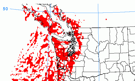
Downpours and thunderclaps. One more day of wild weather
The unstable weather continues and there is some potential for extremely heavy downpours that people should be aware of on the mid Island including around Nanoose and Port Alberni. Click through for details.
-

Slightly soggy week but brightening ahead.
If it isn’t raining at this moment, wait a few minutes and it likely will. 🙂 Here are the predictions for 8AM Monday, 8PM Monday and 2PM Tuesday.
-
Risk of Thunderstorms today, stronger storms early Friday afternoon
Pretty impressive thunder storm maps this morning that are worth sharing with you. Make sure you click through to see them.
-

It feels like June again!
June is historically the last gasp for cool rainy weather before the summer really gets going and it appears that after setting some surprisingly high temperatures to start the month, now we will have to suffer through one of those cool spells. We can see it in the 16 day multi-model forecast through SpotX. Notice…
-

Port Alberni and multiple locations break new records for June 5
It’s official. The Airport got to a sweltering 34.5ºC on Sunday which easily broke the all-time record since 1900 for June 5 which was 33.5º C in 2003. It got even hotter in the City, Alberniweather recorded a high of 35.1ºC, Maquinna got to 35.4º C, Alberni Elementary 35.1ºC and hottest of all, the Neptune station…