No Really – It was a very warm December.
Story of the Month – Exactly 3.5ºC higher than normal
Usually there’s some variation, at least a little, in the averages. This December was different.
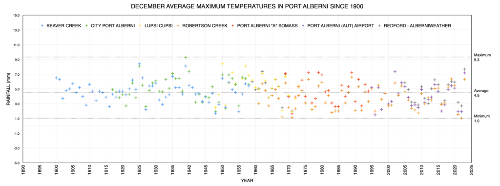
- Average Highs: 3.5ºC above normal
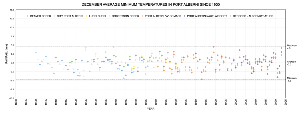
- Average Lows: 3.5ºC above normal
So yes, December 2023 was, according to the official Airport station and compared to Robertson Creek between 1970-2000, exactly 3.5ºC warmer than a normal December. That’s very warm.
Remember, the Paris Climate Accord is trying to get the world to limit warming on a global scale to only 1.5ºC. Our small part of the world is definitely pushing on that barrier.
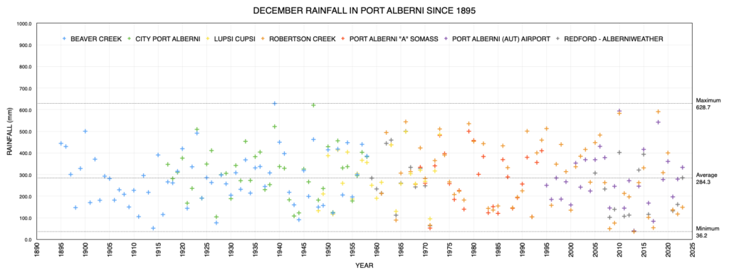
Rainfall was an easy number too. 99%. December was almost exactly the normal amount of precipitation.
But there is a hidden anomaly in there. The Airport measures both rain and snow as ‘precipitation’. We normally receive 29cm of snow.
We certainly did not receive that this year.
So what about the year 2023?
Story of the Year – Fiery Hot and Dry
It’s pretty obvious what stood out this year and that’s the historic wildfire above the highway at Cameron Lake that has caused ongoing worry and headaches.
That fire was caused by a campfire… but it was made much much worse by a historic drought and warm temperatures that extended through the summer and fall and right into December.
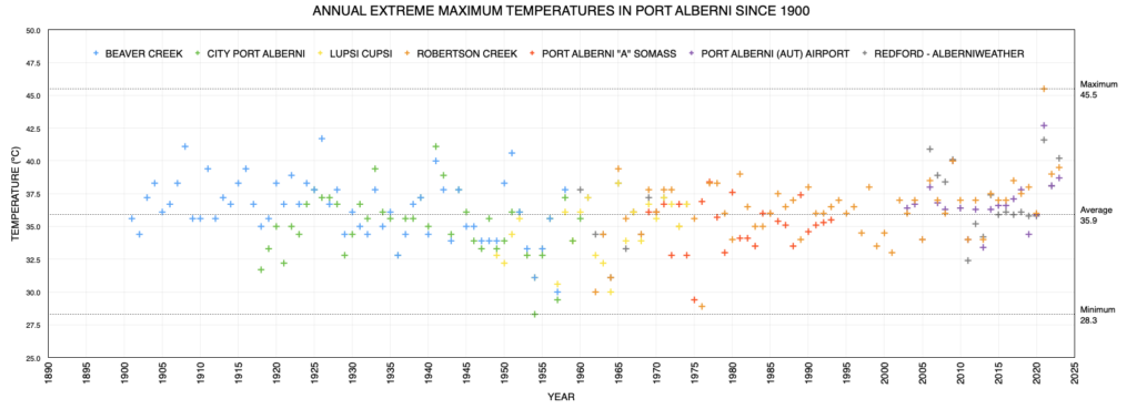
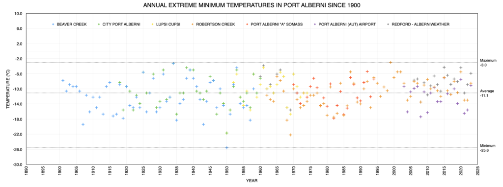
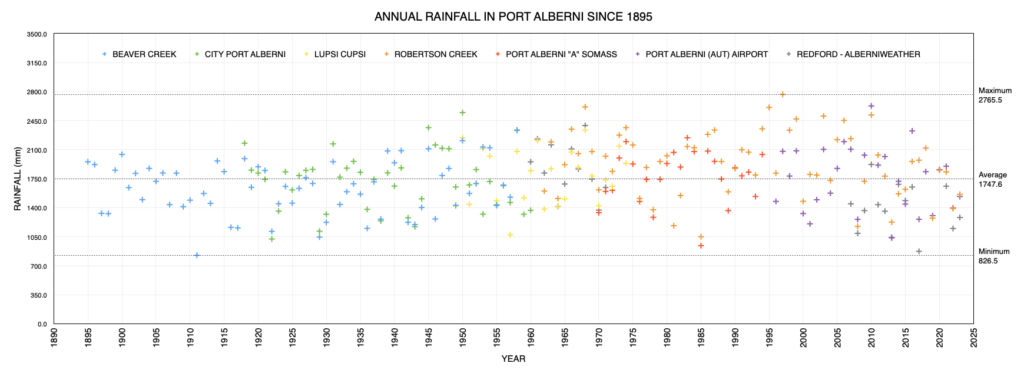
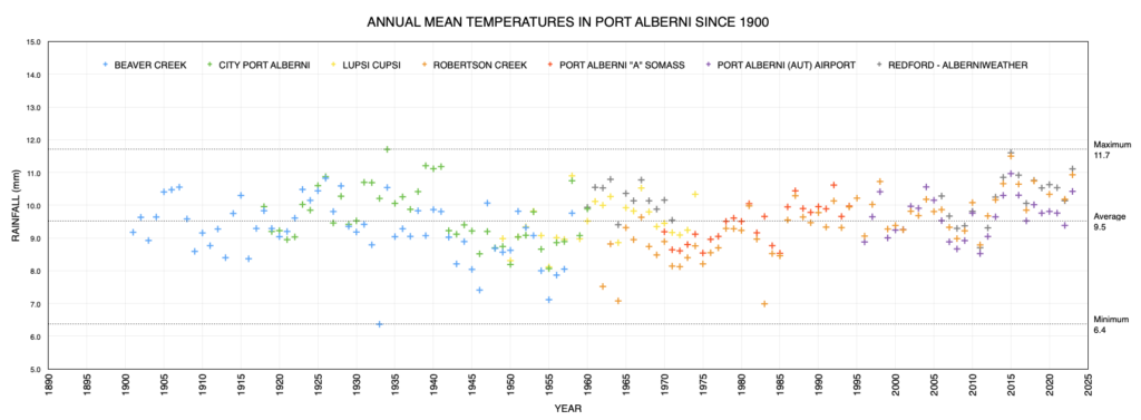
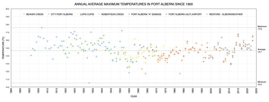
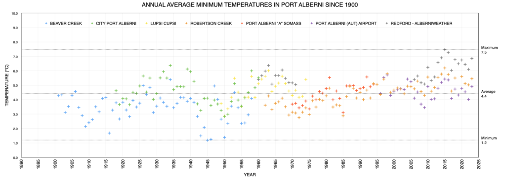
The data below and in the graphs, as you can see in my podcast, makes it pretty clear that 2023 is another step in a long trend of warming in the Alberni Valley.
We were on average 1.1ºC above normal for the year. 1.6ºC for maximums.
And while December managed a nearly normal rainfall amount, it didn’t make up for the rest of the year. We still only received 72% of the normal amount.
The stat that people can maybe really take home and link to how the year felt rainless at times is the Days of Precipitation.
Normally we would see 186 days of at least a little (0.2mm) rain (or snow). This year we saw 161 days.
Normally we would see 95 days with at least 5mm of rain.
This year? 79.
But it’s the heaviest, soaking days, that we are really missing. We only had half the 27 days we normally get with more than 25 mm of rain. 13 instead of 27.
Records!
Many December and Annual Records Set
You can see the December records that were set below in the data section of this post. No All Time Records were set in December but we did have 2 new rain and 5 new high temperature records. December 28th was the closest we came to setting an all time high (for temp) in the Alberni Valley.
By Month the Airport set the following new station records (all time/station in bold):
- Jan: 1 high rain
- Feb: 1 high rain, 1 low temp
- Mar: 1 low temp
- Apr: 2 All Time Station rain records, 1 High Temp.
- May: 4 All Time Station records high temperatures and 2 high temps.
- June: 3 low temps and 2 high temps.
- July: 1 All Time Rain record, 3 high temp.
- Aug: 1 New All Time High Temp, 2 high temp, 2 low temp.
- Sep: 1 high temp, 2 low.
- Oct: 2 low temp
- Nov: 1 high temp
- Dec: 2 rainfall, 5 high temp.
Overall we set 40 new records at the Airport station, 8 of which were all time records for the entire Alberni Valley, 3 for daily rain and 5 for high temperature.
Year 2023 Podcast
I’ve made a podcast looking into how 2023 stacks up against the historical records it goes into great detail.
You’ll be able to see more podcasts at: youtube.com/@alberniweather/podcasts. Hit Subscribe there to be notified.
This Month’s Timelapse
The first full month of timelapse! Snoopy was prominent, Christmas lights, wind and rain.
I’ve created a Youtube Playlist for Monthly Timelapses so they are easy to find. You can check out the live webcam here and daily and hourly timelapses.
Ocean Conditions and El Niño – Moderating?
We continue to be in an El Niño Advisory as of the December 14 update. The first update of the New Year will come out next week. I’ll post a blog entry if anything changes but I expect it to remain pretty much the same.
Their conclusion about the strong El Niño weakening into April and May will likely remain along the lines of December 14, quoted below:
“An event of this strength would potentially be in the top 5 of El Niño events since 1950. While stronger El Niño events increase the likelihood of El Niño-related climate anomalies, it does not imply expected impacts will emerge in all locations or be of strong intensity (see CPC seasonal outlooks for probabilities of temperature and precipitation). In summary, El Niño is expected to continue through the Northern Hemisphere winter, with a transition to ENSO-neutral favored during April-June 2024 (60% chance; [Fig. 7]).”
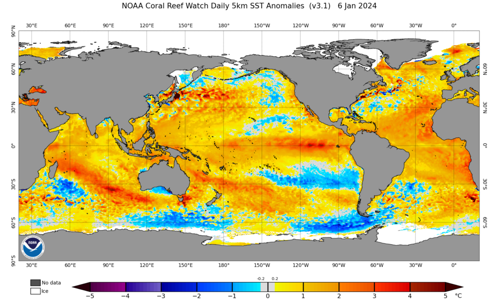
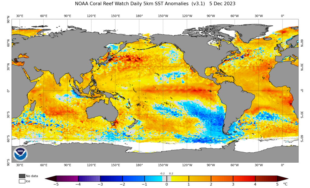
The current image of the Oceans Tempreature Anomalies from January 6 shows (below) shows some major changes in where the heat is concentrated in the oceans compared to a month ago.
Locally, the area of cooler water near the Nortwest Coast of North America has expanded a little and there is less heat between Hawaii and North America. This should indicate less water content in the atmosphere for Atmospheric Rivers to tap into.
The El Niño region along the equator has a few intense zones near South America but generally looks weaker, as expected by the forecast as we approach spring.
Most interesting, but probably not relevant for us is a major shift of cold water coming up from Antarctica to South America. It has changed quite a lot.
Airport Daily Records Set this Month
Set at Airport* since 1994 and compared to Valley stations** for all time.
(since 1895 for rain, 1900 for temperatures, 1980 for snow on ground)
Numerous records set at the Airport this month. Five new high temperature records and two new rainfall records. The December 4 rainfall was recorded at Robertson Creek as well. The values shown for Somass, Robertson Creek and the Airport are now the top three for that date. The closest we came to an All Station record was the Dec 28 high of 10.6ºC, just 1.0º away from breaking the record.
- Dec 4 – Rainfall 61.5mm at Airport (65mm at Robertson Creek). All Time is 87.4 mm at Somass in 1981.
- Dec 5 – High Temp 9.0º C. All Time is 14.4º C at Port Alberni in 1925.
- Dec 17 – High Temp tied with 2018 at 8.2º C. All Time is 13.0º C at Port Alberni A (Somass) in 1979.
- Dec 25 – Rainfall 70.6 mm. All Time is 80.3 mm in 1929.
- Dec 26 – High Temp 11.3º C. All time is 15.0º C at Lupsi Cups in 1950.
- Dec 28 – High Temp 10.6º C. All Time is 11.5º C at Cox Lake in 1997.
- Dec 30 – High Temp 11.6º C. All Time is 15.0º C at Lupsi Cups in 1963.
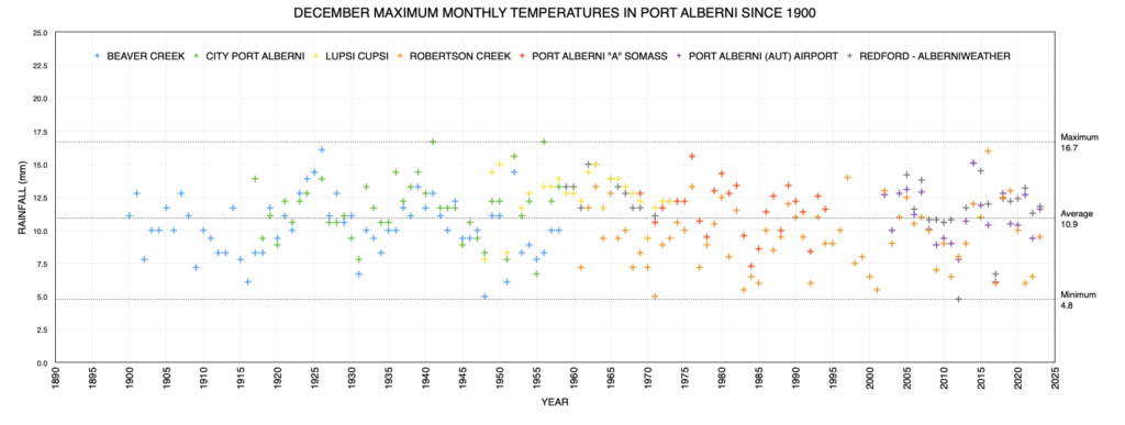
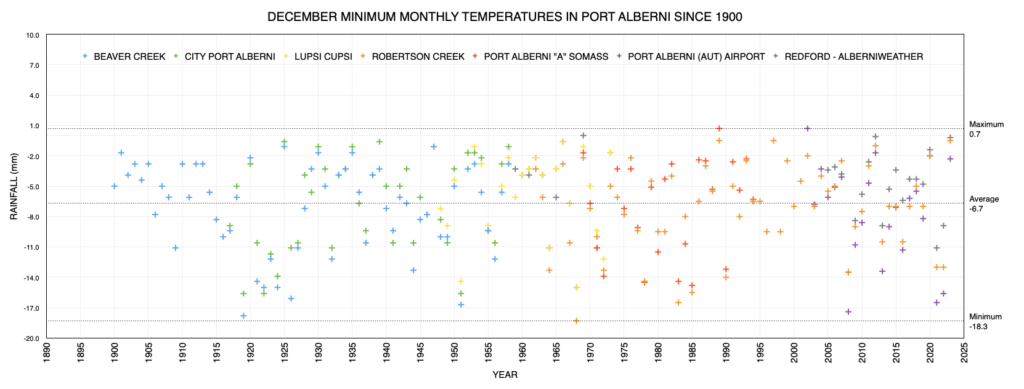
Graphs from Historical Alberni Valley Weather Stations
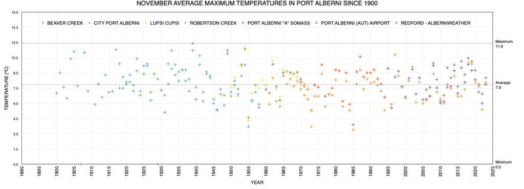
December 2023
Latest values on the far right, click to enlarge/download.
2023 Annual Year-Long Graphs
December City Values Compared to Normal
Please shift your phone to landscape/horizontal to see the table.
| Extreme (ºC) | Average (ºC) | (mm) | Wind (kph) | ||||||
|---|---|---|---|---|---|---|---|---|---|
| Location | Max | Min | Min | Mean | Max | Rain | Dir | Speed | Day |
| Alberniweather | 11.8 | -0.2 | 4.2 | 5.7 | 7.7 | 285.0 | ESE | 64.4 | 26 |
| Dave’s (Uptown) | 11.5 | -0.1 | 4.1 | 5.6 | 7.5 | 407.17 | NA | NA | NA |
| Nick’s (South Port) | 10.8 | 0.1 | 4.1 | 5.4 | 7.1 | 234.4 | NA | NA | NA |
| Kitsuksis (North Port) | 12.1 | -0.9 | 3.9 | 5.6 | 7.8 | 370.3 | NA | NA | NA |
| Alberni Elem | NA | NA | NA | NA | NA | NA | NA | NA | NA |
| Maquinna Elem | NA | NA | NA | NA | NA | NA | NA | NA | NA |
| Extreme (ºC) | Average (ºC) | Average (mm) | Ext. Wind (kph) | ||||||
| Max | Min | Min | Mean | Max | Rain | Dir | Speed | Day | |
| Combined City | 11.8 | -0.9 | 4.1 | 5.6 | 7.5 | 324.2 | ESE | 64.4 | 26 |
| Normal (Somass) 1971-2000 |
0.2 | 2.5 | 4.7 | 275.9 | |||||
| Difference from Normal | +3.9 | +3.1 | +2.8 | +48.3 (117.5%) |
|||||
|
Extreme Day |
15.6 | -14.8 | 111.0 | 64 | |||||
| Max | Min | Min | Mean | Max | Rain (mm) | Dir | Speed | Day | |
| Extreme (ºC) | Average (ºC) | Wind (kph) | |||||||
| Days of Rain | >=0.2 mm | >=5 mm | >=10 mm | >=25 mm | |||||
| Normal | 17.5 | 11.0 | 7.8 | 4.0 | |||||
| This Month (Alberniweather) |
26 | 14 | 7 | 2 | |||||
Official December Airport and Robertson Creek Environment Canada Stations Compared to Normal
Please shift your phone to landscape/horizontal to see the table.
| Extreme (ºC) | Average (ºC) | (mm) | Wind (kph) | ||||||
|---|---|---|---|---|---|---|---|---|---|
| Location | Max | Min | Min | Mean | Max | Precip | Dir | Speed | Day |
| 11.6 | -2.3 | 3.0 | 5.1 | 7.2 | 333.2 | SW | 42 | 9 | |
|
Robertson Creek |
NA | NA | NA | NA | NA | NA | |||
| Normal (Robertson Creek) 1971-2000 |
-0.5 | 1.6 | 3.7 | 336.9 | |||||
| Difference from Normal (from Airport) |
+3.5 | +3.5 | +3.5 | -3.7 (99%) |
|||||
|
Extreme Day |
14.0 | -18.3 | 98.6 | NA | |||||
| Max | Min | Min | Mean | Max | Rain (mm) | Dir | Speed | Day | |
| *New Extreme for Month | |||||||||
| Days of Precipitation | >=0.2 mm | >=5 mm | >=10 mm | >=25 mm | |||||
| Normal | 20.4 | 13.3 | 10.1 | 4.9 | |||||
| This Month (Airport) |
23 | 16 | 10 | 2 | |||||
2023 Annual Values Compared to Normal
Please shift your phone to landscape/horizontal to see the table.
These values are compiled in my own spreadsheet containing all ECCC stations data.
| Extreme (ºC) | Average (ºC) | Total (mm) | |||||||
|---|---|---|---|---|---|---|---|---|---|
| Location | Max | Min | Min | Mean | Max | Rain | |||
| Port Alberni Airport | 38.7 | -9.1 | 4.9 | 10.4 | 15.9 | 1534.6 | |||
| Alberniweather | 40.2 | -5.9 | 6.9 | 11.1 | 16.5 | 1282.2 | |||
| Extreme (ºC) | Average (ºC) | Average (mm) | Ext. Wind (kph) | ||||||
| Max | Min | Min | Mean | Max | Precipitation | Dir | Speed | Day | |
| Normal (Robertson Creek) 1971-2000 |
4.1 | 9.3 | 14.3 | 2134.4 | |||||
| Difference from Normal (Airport) | +0.8 | +1.1 | +1.6 | -599.8 (71.8%) |
|||||
|
Extreme Day |
39.4 | -22.2 | 127.5 | ||||||
| Max | Min | Min | Mean | Max | Precipitation (mm) | Dir | Speed | Day | |
| Extreme (ºC) | Average (ºC) | Wind (kph) | |||||||
| Days of Precipitation | >=0.2 mm | >=5 mm | >=10 mm | >=25 mm | |||||
| Normal | 186.4 | 95 | 65.5 | 26.9 | |||||
| This Year 2023 (Airport) |
161 | 79 | 50 | 13 | |||||
* May have used backup Environment Canada Data source at WeatherStats.ca for Missing Data
** Short Term means since 1994 at the new AVRA Airport. Airport Records are compared to the 30+ year weather stations of record since 1900 (1895 for rain) at Beaver Creek, Port Alberni “City” and Robertson Creek. Note that records pre 1950 may be more likely to over-estimate high temperatures.


