Alberniweather and Port Alberni Summary for September 2023
Story of the Month – Rain returns at the end.
The most important weather event was certainly the first significant rain that finally occurred at the end of the month between the 23rd and 28th. Before then, we had not experienced two days with more than 10mm within the month since mid-April.
September Extremes – And a Global Record
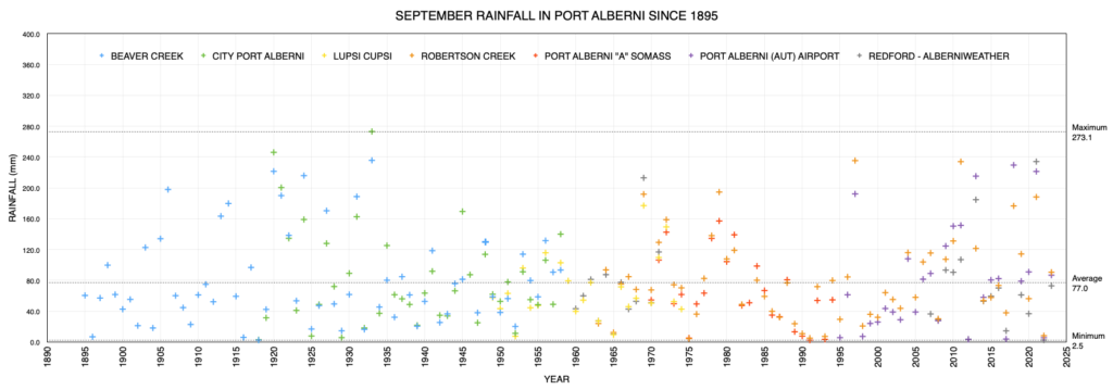
September is often an extreme month with very hot temperatures over 35 still possible as well as sometimes delivering the first frost. Similarly, it’s not uncommon for us to get our first rain event of the fall, breaking the summer dry spell, so while overall rainfall totals are usually only 50-60mm, we often get that in one or two storms. In this respect, this September was surprisingly normal. In fact, our rainfall totals at around 80-100mm depending on the station, were a little higher than normal. Most of this was from the one end of the month storm. Thankfully there did not seem to be any large impacts on the damaged slope above the highway at Cameron Lake.
The headlines around the world are that this September set a stunning global temperature record beating the old September record set just in 2020 by 0.5ºC. This might not sound like a lot but when you’re dealing with an average of a system as large as the Earth, a half degree change in one month is exceptionally big. Overall, for the globe, this September was 0.93ºC warmer than the average September between 1991-2020.
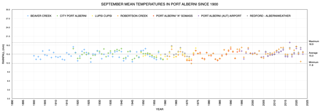
By contrast, the official temperatures at our Airport were only 0.2ºC warmer than the 1970-2000 average, so we were thankfully on the lower end of the scale compared to the rest of the planet. Credit the influence of the Pacific Ocean and that late month storm. We are lucky to live where we do!
El Niño is here – Heating an Already Hot Ocean
Speaking of the Ocean, El Niño is fully underway. The graph (source) shows the sea surface temperatures in the region of the tropical Pacific where El Niño/La Niña reside. Values above the dashed line indicate an El Niño event.
We are very much into the upswing (black line) and the forecasts (coloured lines) show an expectation that this phase of El Niño will peak around November but it is likely we continue in an El Niño state until at least April.
As you can see in the image below, nearly the entire surface of the oceans of the world is above normal. The pulses of El Niño are prominent off the coast of Ecuador and South America. There is extreme heat in the North Pacific off of the coast of Japan and Russia. The waters off Nova Scotia and Newfoundland are very hot as is the Gulf of Mexico and Hudson’s Bay. And don’t forget the high Arctic.

In fact, the waters off of the Pacific Northwest and into the Gulf of Alaska are notable as being some of the only areas with lower than normal sea surface temperatures.
Considering all of these factors, I would expect a warm and potentially very wet winter *if* the jet stream behaves normally and sends us systems off of the Pacific. That area of extreme heat off of Japan is of potential concern if it super charges any late season Typhoons that often swing our way eventually.
If, on the other hand, we get long periods with a weak jet stream, due in large part to the lack of ice in the Arctic, then expect a warm, but drier winter. Exactly what we don’t need to break our current Level 3 Drought.
The greatest probability though is that El Niño will have the larger influence for us, so I lean toward a warm and wet winter, perhaps similar to 2010.
That’s all for this month. More data and comments below!
Airport Daily Records Set this Month
Set at Airport* since 1994 and compared to Valley stations** for all time.
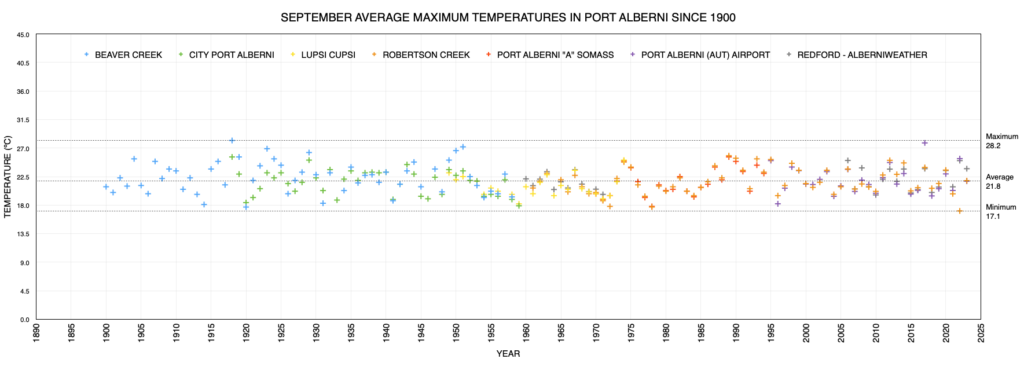
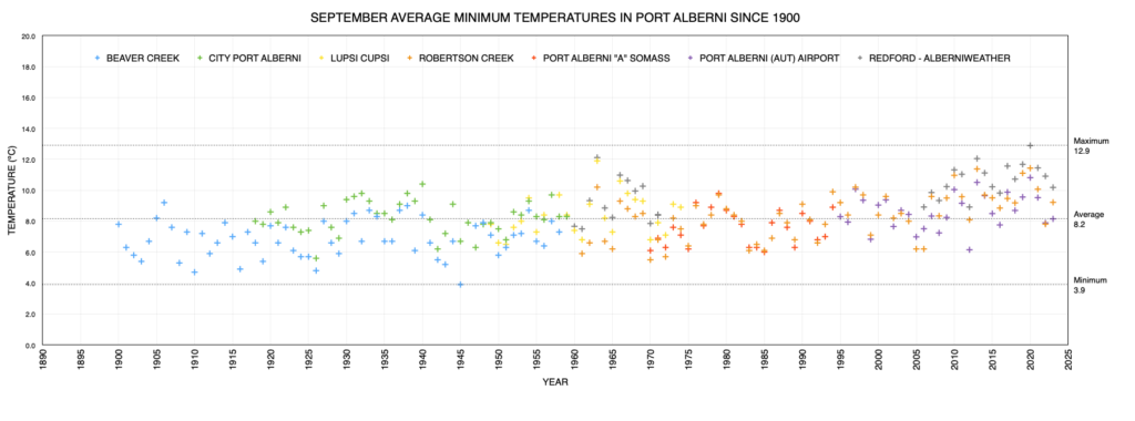
(since 1895 for rain, 1900 for temperatures, 1980 for snow on ground)
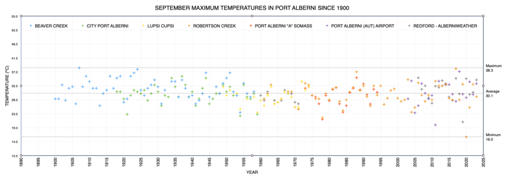
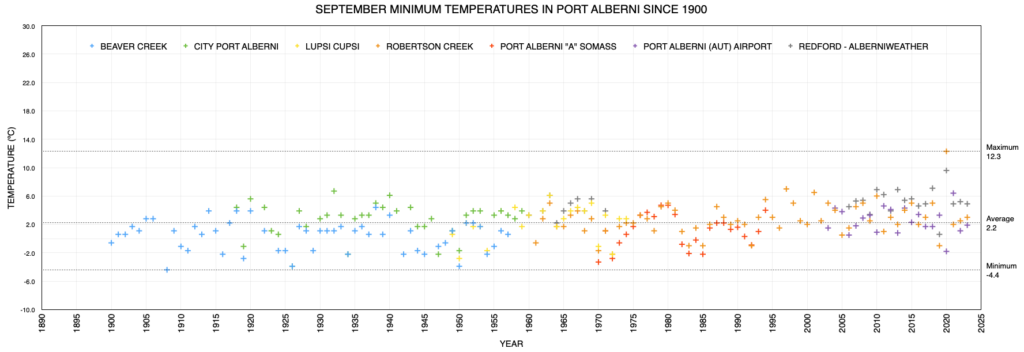
The Airport only set 3 records this month. One high temperature on the 1st, and two low temperatures on the 9th and 21st. None of the Airport values approached all time records for those days or temperatures.
- September 1 – High Temp 30.4ºC at Airport. All Time is 35.0ºC in 1909 at Beaver Creek.
- September 9 – Low Temp 4.9 ºC – All Time is 0.6 ºC in 1945 at Beaver Creek.
- September 21 – Low Temp 2.1 ºC – All Time is -0.6ºC in 1945 at Beaver Creek.
This Month’s Graphs from Historic Alberni Valley Weather Stations
Combining Environment Canada and other Personal Weather Stations
Latest values on the far right, click to enlarge/download.
This Month’s City Values
Compared to Normal
Please shift your phone to landscape/horizontal to see the table.
| Extreme (ºC) | Average (ºC) | (mm) | Wind (kph) | ||||||
|---|---|---|---|---|---|---|---|---|---|
| Location | Max | Min | Min | Mean | Max | Rain | Dir | Speed | Day |
| Alberniweather | 34.4 | 4.9 | 10.2 | 15.7 | 23.7 | 72.9 | SSE | 40.2 | 10 |
| Alberni Elem | NA | NA | NA | NA | NA | NA | NA | NA | NA |
| Maquinna Elem | NA | NA | NA | NA | NA | NA | NA | NA | NA |
| Dave’s (Uptown) | 34.1 | 5.3 | 10.4 | 15.5 | 22.8 | 107.9 | NA | 14.5 | 1 |
| Nick’s (South Port) | 30.8 | 5.6 | 10.6 | 15.0 | 20.9 | 80.6 | NA | 14.5 | 17 |
| Kitsuksis (North Port) | 33.3 | 3.5 | 9.5 | 15.0 | 22.6 | 100.06 | NA | 19.0 | 23 |
| Extreme (ºC) | Average (ºC) | Average (mm) | Ext. Wind (kph) | ||||||
| Max | Min | Min | Mean | Max | Rain | Dir | Speed | Day | |
| Combined City | 34.4 | 3.5 | 10.2 | 15.3 | 22.5 | 90.4 | SE | 40.2 | 10 |
| Normal (Somass) 1971-2000 |
7.6 | 14.7 | 21.7 | 65.1 | |||||
| Difference from Normal | +2.6 | +0.6 | +0.8 | +25.3 (138%) |
|||||
|
Extreme Day at Somass |
35.1 | -3.3 | 58.4 | 39 | |||||
| Max | Min | Min | Mean | Max | Rain (mm) | Dir | Speed | Day | |
| Extreme (ºC) | Average (ºC) | Wind (kph) | |||||||
| Days of Rain | >=0.2 mm | >=5 mm | >=10 mm | >=25 mm | |||||
| Normal | 9.8 | 4.1 | 2.2 | 0.50 | |||||
| This Month (Alberniweather) |
11 | 5 | 3 | 0 | |||||
Official Airport and Robertson Creek Environment Canada Stations Compared to Normal
Please shift your phone to landscape/horizontal to see the table.
| Extreme (ºC) | Average (ºC) | (mm) | Wind (kph) | ||||||
|---|---|---|---|---|---|---|---|---|---|
| Location | Max | Min | Min | Mean | Max | Precip | Dir | Speed | Day |
| 32.6 | 1.6 | 8.2 | 15.0 | 21.8 | 86.8 | ESE | 35 | 26 | |
|
Robertson Creek |
29.0 | 3.0 | 9.2 | 15.6 | 21.9 | 90.6 | NA | ||
| Normal (Robertson Creek) 1971-2000 |
8.0 | 15.0 | 22.0 | 72.1 | |||||
| Difference from Normal (from Airport) |
+0.2 | +0.2 | -0.2 | +14.7 (120%) |
|||||
|
Extreme Day |
37.0 | -2.2 | 58.2 | NA | |||||
| Max | Min | Min | Mean | Max | Rain (mm) | Dir | Speed | Day | |
| *New Extreme for Month | |||||||||
| Days of Precipitation | >=0.2 mm | >=5 mm | >=10 mm | >=25 mm | |||||
| Normal | 10.8 | 4.1 | 2.1 | 0.66 | |||||
| This Month (Airport) |
12 | 6 | 3 | 0 | |||||
* May have used backup Environment Canada Data source at WeatherStats.ca for Missing Data
** Short Term means since 1994 at the new AVRA Airport. Airport Records are compared to the 30+ year weather stations of record since 1900 (1895 for rain) at Beaver Creek, Port Alberni “City” and Robertson Creek. Note that records pre 1950 may be more likely to over-estimate high temperatures.


Comments
One response to “September 2023 Summary: Port Alberni’s part in the Hottest Recorded Month on Earth So Far.”