The good news is we look to be set into long term pattern of cool, and clear, weather that is going to be quite nice… the potentially bad news is it will be punctuated every few days with a chance of rain or snow as bands of moisture invade the area periodically. The most interesting might be in a week or so when it might get really cold… but more on that in a minute. First, here’s what to prepare for today.
We should start Tuesday pleasant. Frosty but only partly cloudy. Clouds will thicken through the day and overnight. Then we have a potential for either rain, or wet snow, depending as it always does, completely on how close we are to 0ºC.
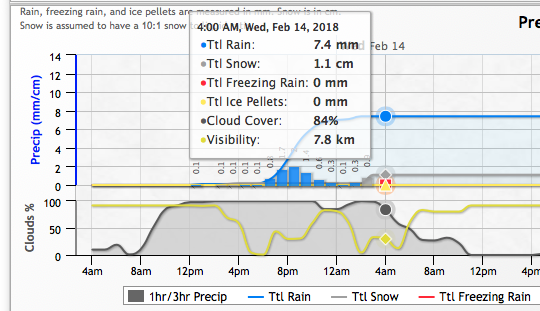
Here are the various models from SpotX. As you can see, they are more than a little mixed in their predictions for Port Alberni (at sea level).
The High Resolution Canadian “LAM” says 5mm of rain starting around 5PM.

The Canadian “GEM” says 7cm of snow starting at 5PM.

The U.S. High Resolution Rapid model says just 2.5mm of rain starting around 7PM.
The US NAM has a mix, but the snow is just tiny flurries starting in the afternoon, unlikely to accumulate, with the majority being rain starting around 7PM and then finishing with it changing to snow early Wednesday morning. I actually like this one the best so far.
The US GFS is similar to the NAM in that it has rain starting at 7PM and then finishing with snow in the early morning Wednesday.
Finally, last night’s UWash model run predicted only high elevation snow. Nothing at sea level for anywhere on the Island.
I’m going to say that given that it is -0.6ºC right now and clouding over, which will limit our daytime heating, that we will see maybe a start of precipitation around 4PM today of very light flurries followed by a switch to showers in the evening and then perhaps wet snow overnight.
However, leave the possibility open for either an all rain event, or a snow event. And if you are closer to the mountains, or further inland, then snow is much likely.
Once things pass Wednesday morning we should clear up again and be sunny until Friday.
In the longer range forecast, for next week as I mentioned before, there are some very cold predictions! It might be very nice and sunny, but we could see lows down to -10ºC! Anytime we get that low… and then a pacific storm comes through… you know what that can mean. Keep that in mind as you enjoy the relatively mild temperatures this week.
Happy Tuesday that Feels Like Monday!


