
The forecast is pretty simple over the next few days so I won’t spend too much time on it. You should expect rain or showers to continue for the rest of the week, but particularly Wednesday afternoon and evening, Thursday morning and Thursday night and then Friday afternoon.
So… really… just expect rain always. 🙂
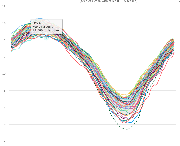
Arctic Sea Ice hits new low.
In other news, the Arctic has set another record in the satellite data (1979). This time of year is the time, at the spring equinox, is traditionally the time when we see the largest amount of sea ice in the Arctic regions.
This year’s ‘maximum’ for sea ice appears to be the lowest on record.
You can see all of the years since 1979 here.
Below are three graphs, they are each the same, but show data points for “Day 80” (the 80th day of the year, March 21) for 1979, 2007 (10 years ago) and 2017.


So we can see that even during the dark winter months the Arctic is demonstrating a clear trend to having less ice. Between 1979 and today, the difference is loss in maximum sea ice is 2.2 million square kilometres.
In comparison, British Columbia has an area of 944 thousand square kilometres. So the Arctic has lost over 2x the area of British Columbia in the span of 38 years.
If you’re wondering, the difference on the minimum sea ice in September is of course much more dramatic. The highest amount of ice in September was measured at 7.555 million square kilometres. Last year we go down to 4.1 million and the lowest ever was in 2012 at 3.4 million square kilometres. That is a loss equal to 4 British Columbias of ice.
That loss of cooling from our northernmost regions *will have* an ongoing effect on our weather patterns here in the mid-latitudes.