(Expect rain to start before noon Friday – Full weekend Forecast tomorrow)
February was so out of whack that even though March was again significantly warmer than normal it was actually only slightly warmer than February. So here goes… the easiest prediction you will ever see made. I predict there will be no significant snow pack recorded at the Jump Creek station for the 2014-2015 season. I do not know if that has ever happened before. No doubt others with access to more data will be digging that up.
Extreme February Highs actually higher than March highs – Rain makes Snow Pack History
Temperatures well above normal and rain only at low and high elevations.
We were well above normal for the month. The notable thing, as you can see in the data, is even though all of our low, median and high averages were well above normal, more than 2ºC, the average day high was actually lower than February! This just shows how extreme February was.
The snowpack data continues to tell the most important story. The dark blue line shows that the snowpack is basically zero at Jump Creek south of Mt. Arrowsmith.
 Unlike last year (in green above) when “old man winter” returned with a significant snowfall event in mid February both at low and high elevations, this year we’ve had nothing. In fact, as you will see in this months record listings below, last year we got a couple days of record cold before the snow hit. No such luck this year. Winter is Missing in Action.
The April 1st BC River Forecast Centre report underlines this message.
Temperatures across British Columbia continued to be well above normal through the month of March. Temperatures were typically 1-3°C above normal along coastal areas of BC, and 3-5°C above normal across the interior. March sea surface temperature anomalies in the Pacific Ocean off the shores of British Columbia have continued to be 1-3°C degrees above normal, and NOAA’s National Climatic Data Centre is reporting that temperature anomalies off the BC coast have been at record high levels through the winter of 2014-15.
…..
The extremely low snow packs in southwest BC and low snow packs in the low to mid-elevation terrain, are the result of both warmer temperatures and drier conditions through the winter. A high proportion of precipitation has been delivered as rain rather than snow. Snow basin indices are at historic minimum values (30 years of record) in the Lower Fraser, South Coast, and Vancouver Island.
….
Extremely warm Pacific Ocean temperatures persist off the BC coast. El Nino conditions are present in the equatorial Pacific, and there is a moderate likelihood of those conditions persisting into the summer. However, NOAA is suggesting that the influence of El Niño through the spring is likely to be small given the weak nature of the El Niño conditions. Environment Canada is forecasting a very high likelihood of above normal temperatures over the April to June period across British Columbia, particularly for the coastal areas.
…..
With extremely low snow packs in the Lower Fraser, South Coast, Skagit and Vancouver Island, runoff from snow melt will be limited. Seasonal low flows are expected to occur earlier than normal this year; very low flows can be expected in the summer unless significant rainfall occurs through the spring and summer.
Rainfall measuring woes continue at Airport.
Once again, the Airport station only recorded 12 days of values for precipitation. All others are listed as “missing” or simply don’t exist.
El Niño update
The NOAA just released their El Niño commentary for April today. We are officially experiencing a “weak El Niño”. The update says:
There is an approximately 70% chance that El Niño will continue through Northern Hemisphere summer 2015, and a greater than 60% chance it will last through autumn.
Even though the El Niño is weak this time around and does not appear to be likely to strengthen, at least at this point, it will still likely have a small impact on our weather. This UBC page has a good rundown of what El Niño does to the weather and climate across Canada.
In the summer months, it generally leads to warmer waters which impact salmon migration routes and bring in southerly species like mackerel and tuna. Since we already had “historic” high sea surface temperatures before the El Niño got established, I would assume this would simply strengthen that unusually warm water.
If the El Niño continues through fall and winter we can expect less snow… however again, we have already experienced a historic low snow pack year so an El Niño would simply exasperate that trend.
In all, it is shaping up to be a very warm and dry spring, summer and fall.
Outlooks — Spring and Summer looking warm and dry.
That brings us to the seasonal outlooks.
The NMME outlooks are available here. Take with a grain of salt.
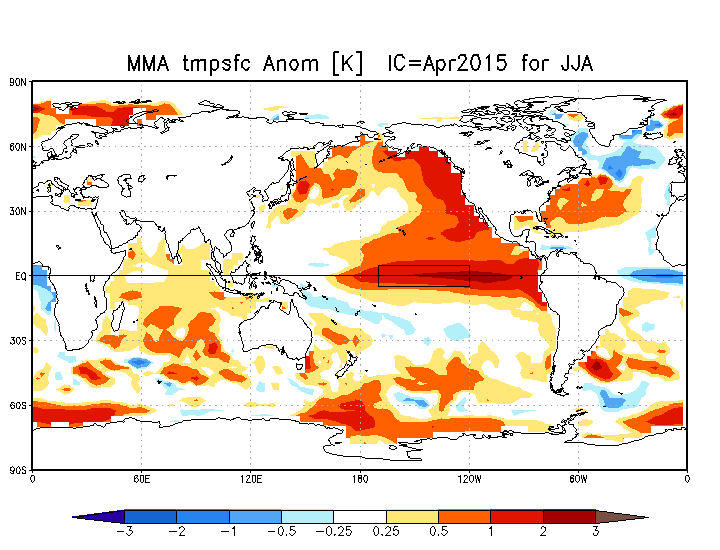
Outlook for Temperature, Precipitation and Sea Surface Temperature for May, June, July (MJJ):
2ºC Above Normal and Drier than normal.
(no change from last months prediction)
Outlook for Temperature Precipitation and Sea Surface Temperature for June, July, August (JJA):
2ºC Above Normal and normal precipitation.
(compared to last months prediction, same temperature, drier)
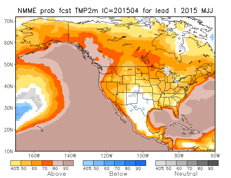
Here are the probabilities (the confidence levels) for those forecasts.
It all looks nothing but hot and dry.
That’s it! Check the data for the month is below!
Daily records set this month at the Airport (and compared to other stations for “All Time”)
One new low, four new Airport highs, three rain, one all time rain.
- March 4 low -3.8º C : #1 is -15.0º C in 1955 (and others).
- March 7 high 17.0º C: #1 is 21.1º C in 1905 at Beaver Creek.
- March 8 high 16.8º C: #1 is 24.4º C in 1905 at Beaver Creek.
- March 16 high 13.5º C: #1 is 23.3º C in 1947 at Beaver Creek.
- March 20 rain 45.6 mm: #1 is 74.4 mm in 1963 at Robertson Creek.
- March 21 high 13.8º C: #1 is 22.2º C in 1914/40 at Beaver Creek.
- March 29 rain 41.0 mm: ALL TIME Record (beats 36.6 mm in 1983 at Robertson Creek)
- March 30 rain 22.4 mm: #1 is 46.7 mm in 1909 at Beaver Creek.
Short Term Airport Records are compared to the 30+ year weather stations of record since 1900 at Beaver Creek, Port Alberni City and Robertson Creek.
March 2015 Minimum, Overall and High Daily Average Temps See last month’s and last March’s summary.
Alberniweather: 4.9º C, 8.2° C, 12.9º C
Alberni Elementary School : 4.6º C, 8.2º C, 13.0° C
Maquinna Elementary School: 4.6º C, 7.8º C, 12.4° C
Neptune Canada Station: 3.9° C, 7.5º C, 13.2º C
Overall City Average: 4.50° C, 7.93º C, 12.88º C
Environment Canada Airport: 3.0º C, 7.8° C, 12.5º C
1981-2010 Env Can Normal (Rbrtsn Creek): 0.7º C, 5.7º C, 10.5° C
Precipitation for March 2015:
Alberniweather: 229.1 mm
AES: 238.6 mm
MAQ: 276.2 mm
NEP: NA (not measured)
Overall City Average: 248.0 mm
EC: —- (196.0 mm measured from only 12 days of reported data!)
1981-2010 Env Canada Normal (Robertson Creek): 239.6 mm
City Stations Temperature Difference from normal:
+3.8° C, +2.2º C, +2.4ºC
Official (Airport) Temperature Difference from normal:
+2.3º C, +2.1ºC, +2.0ºC
City Stations Precipitation difference normal:
+8.37 mm (103.5% of normal)
Official (Airport) Precipitation difference from normal:
—- not enough data
*Denotes incomplete data for the month
Comparison to recent Marchs at Alberniweather (unless specified)
- 2014: See the March 2014 Summary Here. We were warmer this year both at Alberniweather and the Airport and got the same rain.
- 2013: Warmer this year than 2013 and wetter.
- 2012: Way warmer this year than 2012 but same rain.
- 2011: Way warmer this year than 2011 but not as wet.
- 2010: Warmer than this El Niño year and wetter.
- 2009: Way warmer this year than 2009. 2009 was drier.
- 2008: Way warmer and a lot more rain this year than 2008.
- 2007: Similar warmth to 2007 but wetter.
- 2006: Warmer this year than 2006 and a lot wetter.


