February continues the Winter Drought
The Podcast of this February Summary
Hit Subscribe there to be notified.
Story of the Month and the Season – Half the normal rain
Only two records set this month, a heat record on the 1st, and rain on the 2nd to last day.
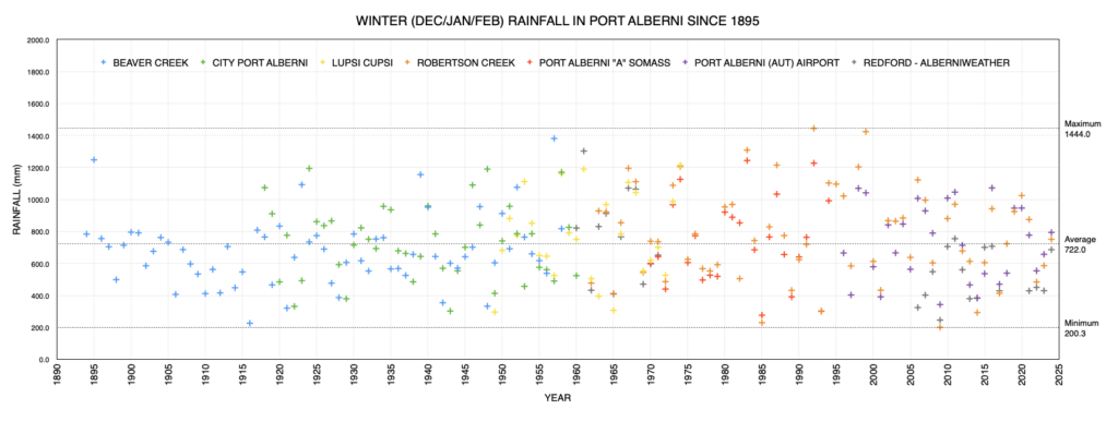
It was a relatively calm and dry month. We only received half the normal total of rain and most of that on that 2nd to last day. We had a normal number of days of rain in total but much less heavier days. This was true of the winter season as well. Normally we’d have 13 days of rain over 25mm between December and March. This year only 7. Normally we’d have 28 days with more than 10mm of rain. This year, we managed just 22.
So while it may have felt relatively normal, because we had 57 days where some moisture was recorded (59 is normal)… the accumulation wasn’t up to snuff.
Overall for the Winter we received 85% of normal rain.
Not cold enough for snow.
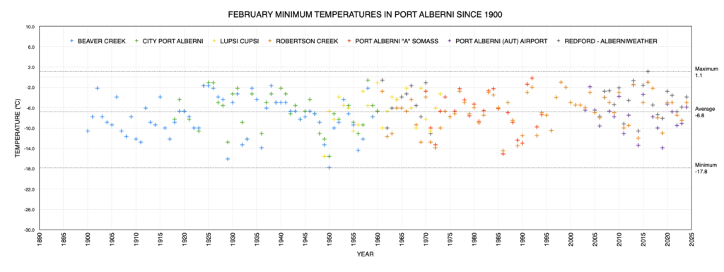
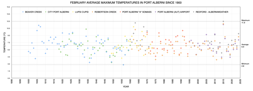
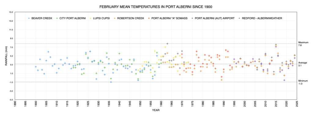
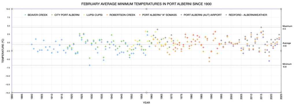
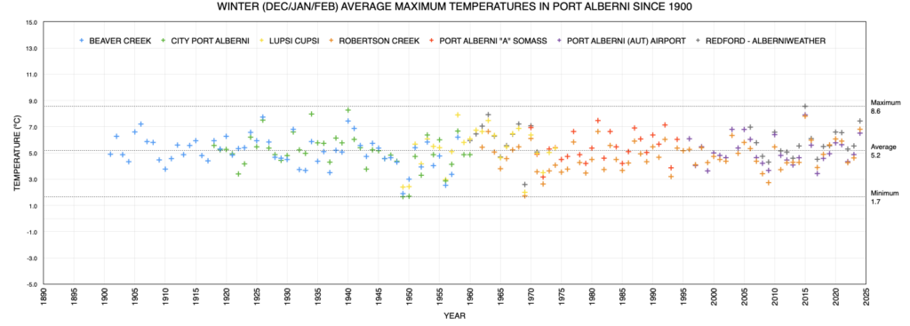
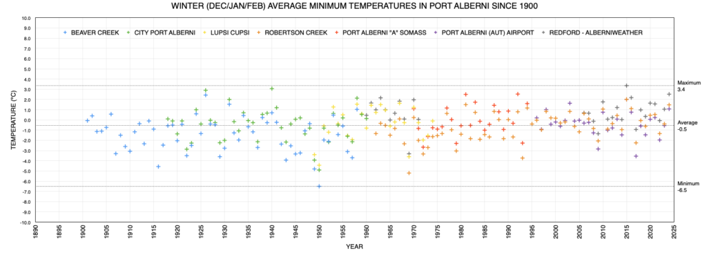
The lack of snow has been notable this winter and we saw that in the average temperatures. The normal average for minimum temperatures in the City in February is 0.1ºC. This month it was 2.2ºC in the City. At the Airport the normal is -0.8ºC, it was +1.0ºC.
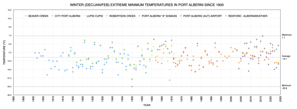
For the winter as a whole, the average minimum was also easily above freezing.
Snowpack – A bright Spot
Slight recovery for March
The good news is the rain on the last days of the month and into March have helped to restore some of the snowpack on Vancouver from below 30% in mid-february to 50% on March 1st. That may continue to rise this week and next. A final reprieve before spring sets in. While it’s not going to solve the drought, it will at least help.
This Month’s Timelapse
This month’s timelapse a little quieter!
I’ve created a Youtube Playlist for Monthly Timelapses so they are easy to find. You can check out the live webcam here and daily and hourly timelapses.
Airport Daily Records Set this Month
Set at Airport* since 1994 and compared to Valley stations** for all time.
(since 1895 for rain, 1900 for temperatures, 1980 for snow on ground)
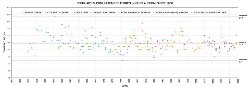
Only one actual new record was set at the Airport this month, for rainfall on February 28. The high temperature was tied with 2005. Neither of these records broke the all time records set early in the last century.
- Feb 1 – High Temp 11.0ºC (tie with 2005). All Time is 12.2º C at Beaver Creek in 1906 and 1924.
- Feb 28 – Rainfall 50.1 mm. All Time is 94.7 mm at Port Alberni in 1947.
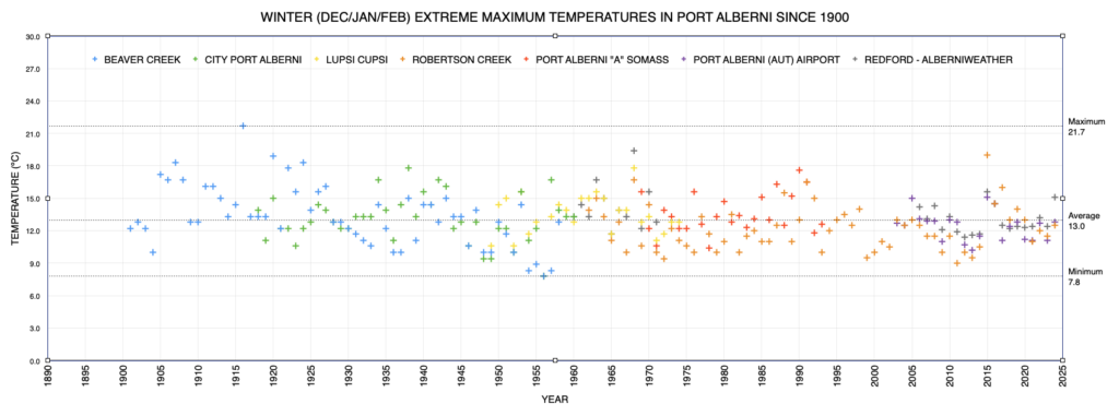
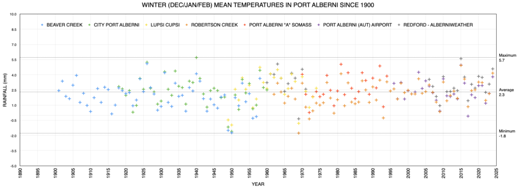
Graphs from Historical Alberni Valley Weather Stations
February 2024
Latest values on the far right, click to enlarge/download.
Winter 2023 – 2024
February City Values Compared to Normal
Please shift your phone to landscape/horizontal to see the table.
| Extreme (ºC) | Average (ºC) | (mm) | Wind (kph) | ||||||
|---|---|---|---|---|---|---|---|---|---|
| Location | Max | Min | Min | Mean | Max | Rain | Dir | Speed | Day |
| Alberniweather | 15.1 | -3.9 | 2.3 | 5.1 | 9.3 | 110.5 | SE | 57.9 | 28 |
| Dave’s (Uptown) | 14.6 | -3.7 | 2.4 | 4.9 | 8.8 | 142.48 | NA | NA | NA |
| Nick’s (South Port) | 11.1 | -3.1 | 2.3 | 4.6 | 7.7 | 93.56 | NA | NA | NA |
| Kitsuksis (North Port) | 14.5 | -4.9 | 1.9 | 4.8 | 9.2 | 132.33 | NA | NA | NA |
| Alberni Elem | NA | NA | NA | NA | NA | NA | NA | NA | NA |
| Maquinna Elem | NA | NA | NA | NA | NA | NA | NA | NA | NA |
| Extreme (ºC) | Average (ºC) | Average (mm) | Ext. Wind (kph) | ||||||
| Max | Min | Min | Mean | Max | Rain | Dir | Speed | Day | |
| Combined City | 13.8 | -3.9 | 2.2 | 4.6 | 8.8 | 119.7 | SE | 57.9 | 28 |
| Normal (Somass) 1971-2000 |
0.1 | 3.6 | 7.1 | 234.4 | |||||
| Difference from Normal | +2.1 | +1.0 | +1.7 | -114.7 (51%) |
|||||
|
Extreme Day |
17.6 | -15.1 | 96.0 | 48 | |||||
| Max | Min | Min | Mean | Max | Rain (mm) | Dir | Speed | Day | |
| Extreme (ºC) | Average (ºC) | Wind (kph) | |||||||
| Days of Rain | >=0.2 mm | >=5 mm | >=10 mm | >=25 mm | |||||
| Normal | 16.2 | 10.1 | 7.4 | 3.0 | |||||
| This Month (Alberniweather) |
15 | 4 | 2 | 1 | |||||
Official January Airport and Robertson Creek Environment Canada Stations Compared to Normal
Please shift your phone to landscape/horizontal to see the table.
| Extreme (ºC) | Average (ºC) | (mm) | Wind (kph) | ||||||
|---|---|---|---|---|---|---|---|---|---|
| Location | Max | Min | Min | Mean | Max | Precip | Dir | Speed | Day |
| 12.0 | -5.9 | 1.0 | 4.5 | 8.0 | 114.4 | ESE | 49 | 16 | |
|
Robertson Creek |
12.5 | -5.0 | 1.4 | 5.1 | 8.7 | 105.1 | NA | ||
| Normal (Robertson Creek) 1971-2000 |
-0.8 | 2.8 | 6.3 | 278.9 | |||||
| Difference from Normal (from Airport) |
+1.8 | +1.7 | +1.7 | -164.5 (41%) | |||||
|
Extreme Day |
16.7 | -14.5 | 105.6 | NA | |||||
| Max | Min | Min | Mean | Max | Precip (mm) | Dir | Speed | Day | |
| *New Extreme for Month | |||||||||
| Days of Precipitation | >=0.2 mm | >=5 mm | >=10 mm | >=25 mm | |||||
|
Normal |
18.4 | 11.7 | 8.5 | 4.0 | |||||
| This Month (Airport) |
14 | 6 | 2 | 1 | |||||
This Winter’s Values Compared to Normal
Please shift your phone to landscape/horizontal to see the table.
These values are compiled in my own spreadsheet containing all ECCC stations data.
| Extreme (ºC) | Average (ºC) | Total (mm) | Wind | ||||||
|---|---|---|---|---|---|---|---|---|---|
| Location | Max | Min | Min | Mean | Max | Precip | |||
| Port Alberni Airport | 12.8 | -13.6 | 1.1 | 3.8 | 6.5 | 793.8 | |||
| Alberniweather | 15.1 | -3.9 | 2.5 | 4.6 | 7.4 | 685.9 | |||
| Extreme (ºC) | Average (ºC) | Total (mm) | Ext. Wind (kph) | ||||||
| Max | Min | Min | Mean | Max | Precipitation | Dir | Speed | Day | |
| Normal (Robertson Creek) 1971-2000 |
-0.9 | 1.9 | 8.1 | 924.1 | |||||
| Difference from Normal (at Airport) | +2.0 | +1.9 | -1.6 | -130.3 (85.9%) |
|||||
|
Extreme Day |
16.7 | -22.2 | 127.5 | 43 | |||||
| Max | Min | Min | Mean | Max | Precipitation (mm) | Dir | Speed | Day | |
| Extreme (ºC) | Average (ºC) | Wind (kph) | |||||||
| Days of Precipitation | >=0.2 mm | >=5 mm | >=10 mm | >=25 mm | |||||
| Normal | 59.1 | 37.6 | 28.3 | 13.1 | |||||
| This Month (Airport) |
57 | 31 | 22 | 7 | |||||
* May have used backup Environment Canada Data source at WeatherStats.ca for Missing Data
** Short Term means since 1994 at the new AVRA Airport. Airport Records are compared to the 30+ year weather stations of record since 1900 (1895 for rain) at Beaver Creek, Port Alberni “City” and Robertson Creek. Note that records pre 1950 may be more likely to over-estimate high temperatures.


