Update 5:30PM — WEATHER OFFICE WEBSITE DOWN.
https://twitter.com/alberniweather/status/944741180914331648
Here is the Snowfall Warning for West Vancouver Island and the Special Weather Statement for East and Inland Vancouver Island.
Snowfall Warning for West Coast
Issued at 2017-12-23 23:31 UTC by Environment Canada:
Snowfall warning issued for:
West Vancouver Island, B.C. (081400)Current details:
Snowfall, with total amounts of about 10 cm is expected.Heavy snow on Sunday for North and West Vancouver Island.
A frontal system will approach Vancouver Island tonight and with cold arctic air in place along the BC Coast, heavy snow is expected during the day on Sunday.
Snow is forecast to begin in earnest early Sunday morning and ease to flurries late in the day. Snowfall accumulations exceeding 10 cm are possible, especially for inland areas and over higher terrain. Communities along the immediate coast of West Vancouver Island can expect snow to be mixed with rain at times and lesser snowfall accumulations.
Strong southeasterly winds will develop along the immediate coast tonight and continue through the day on Sunday. Localized blowing snow is also possible.
Rapidly accumulating snow could make travel difficult over some locations.
Please continue to monitor alerts and forecasts issued by Environment Canada. To report severe weather, send an email to ec.tempetepacifique-pacificstorm.ec@canada.ca or tweet reports using #BCStorm.
SWS for Inland and East Vancouver Island
Issued at 2017-12-23 23:30 UTC by Environment Canada:
Special weather statement continued for:
Inland Vancouver Island, B.C. (081500)
East Vancouver Island, B.C. (081300)
Special weather statement ended for:
West Vancouver Island, B.C. (081400)Current details:
If you have been dreaming of a white Christmas this year, your dreams may come true.The likelihood of some snow is increasing as a weak frontal system over the Pacific approaches the BC Coast this weekend, reaching Vancouver Island on Sunday.
A ridge of high pressure will remain over the BC Interior into at least next week, spilling arctic air into the Georgia Basin. Around the south coast, daytime highs will struggle to rise above the freezing mark.
At present, snow is expected to develop across Vancouver Island during the day on Sunday and spread to the mainland coast by early evening. Confidence is increasing that snowfall amounts will range from 2 to 4 cm for the mainland and 5 to 10 cm over Vancouver Island.
If you have travel plans on Christmas Eve, please monitor forecasts and statements for updates.
Please continue to monitor alerts and forecasts issued by Environment Canada. To report severe weather, send an email to ec.tempetepacifique-pacificstorm.ec@canada.ca or tweet reports using #BCStorm.
Maybe… JUST MAYBE 🙂
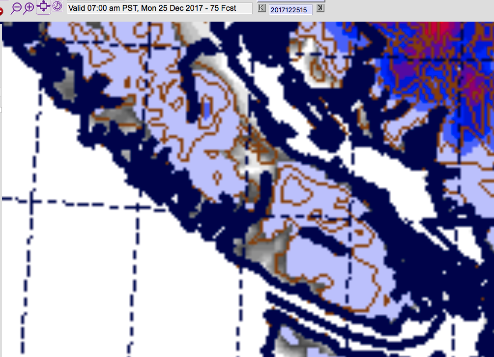
The Saturday morning UWash model has snow on the ground Christmas Morning in Port Alberni… click through for your detailed wish list! :+)
Not a lot… the grey colours mean less than 10cm. But it might be JUST enough to give us that white Christmas.
There are a few things you want to wish for tonight and tomorrow in order for this dream to come true:
- We need it to be cold tonight! The colder the better. The models say we will get down to just below freezing. The lower the better!


- Currently the flurries are slated to start around 2PM Sunday. It would sure be great if it was a little later, like after sundown. 🙂
 It should be done snowing before 9PM Sunday night though it might linger a little longer on the East side of the Island and it will stop latest on the South end as the front moves from north to south.
- Finally, on Christmas Morning… the easterly winds might start up… this is our chance at the “Perfect” Christmas (snow on the ground and snowflakes in the air!). The best chance is definitely nearer the inland mountains (Alberni Valley, Cowichan Valley) or maybe in Parksville, Bowser, or Nanaimo. If it is stronger than expected, the whole Island might get a taste.

Lets all just hope.
Have a very very Merry Christmas and Happy Holidays to everyone out there!
FINGERS CROSSED!


