
Category: Storm
-

Wednesday showers. Thursday rain. Weekend variable. Keep an eye on snow melt.
This is the bleary eyed, I-stayed-up-until-1AM-on-a-school-night-because-i-was-glued-to-the-election edition so forgive me for being brief. There is what appears to be a system coming with showers starting after noon today. Here is the imagery. Most the precipitation is focus in the central Island mountainous regions to start. However, overnight and into Thursday morning the rain will intensify…
-

Risk of Thunderstorms with heat this afternoon.
The fog should clear before noon and it will heat up quickly. Last nights model run moderated temperatures a little bit but a high to 24 or 25°C is definitely within sight. Environment Canada also has the threat of thunderstorms in the area as do other forecasters. The UWash model does not show anything but…
-

Rain. Rain. Rain. Sun. Rain. Rain. Rain.
There. That about covers it from today through to Monday. 😀
-

Showers Monday, Break Tuesday, Rain Wednesday
A short post as I am working on the March summary. This mornings rain will ease but showers will continue throughout the morning and early afternoon ending by 2PM. The rain will mostly be focused on the West coast and central island, whereas the East Island mostly dries out. There will be a nice break…
-
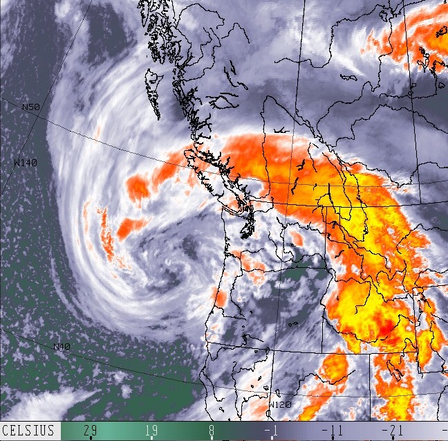
The barometer is dropping. Wind is coming.
The barometer never lies. A storm is on the way. The satellite never lies either. That’s a doozy of an April storm coming our way. It looks like the center is roughly around Oregon right now. It will slowly creep north all day according to the model below. The last image indicates the low will come ashore around…