If there are other critical pages I will add them here.
9PM August 16 – Final Update
There have not been any major updates to the size or perimeter. The size is currently 3671ha (36.7 square kilometres)
The fire has calmed down and BCWF and their supporting organizations (I saw Oyster River VFFs in town yesterday!) are hard at work on containment, extinguishing, and mopping up. I am going to optimistically say that the worst of the fire danger is hopefully over but the official word can only come from BCWF. Evacuation Alerts and Orders remain in place.
If the fire sparks up again I’ll make a new post but I don’t think I have anything more to contribute for this event at this time. It looks like just steam and smouldering campfire smoke for now.
Thank you everyone who has reached out to say they appreciated these updates. I am grateful to be able to share this information with you. If you are new to Alberniweather and would like to follow the regular posting or videos, check out Alberniweather on Socialbc.ca and on Youtube. You can also join our Alberniweather – Weather Nerds Signal Group chat.
I think we dodged a bullet thanks to the Northerly wind on those first two days, but also, we have an incredible service in BCWF and all the supporting government and other orgs that do everything in their power to keep us safe.
Take care out there.
9:30PM Aug 15 – Small size increase – new perimeter – new Water Restrictions
Good news this evening. The fire has only increased 200 hectares to 3668 hectares (36 square kilometres). This is of course a little unbelievable considering a 200 hectare fire by itself would probably be one of the largest fires in this area.
A little History – The Biggest Fire?
Is the Underwood Fire the largest ever in the since the arrival of settlers to the Alberni Valley? I’m not sure.
That fire started on August 16 from a fallen Hydro pole. It grew to 6264 acres (2534 hectares) before it was brought under control on August 30th after huge efforts on the ground and in the air (both Philippine and Hawaii Mars). The last smoke was seen on October 20 that fall. I remember seeing the mountain sides along Taylor Arm still covered in ‘burnt sticks’ when I was a kid in the 1980s.
The still out-of-control Underwood Fire is now 3668 hectares, or 9063 acres.
New Perimeter – no closer to Port Alberni
The fire remains 5.8km away from Anderson and Ship Creek Road. In fact, that’s 100m further away than the last perimeter. So the fire has not come appreciably closer in the past two days. Good news!
Rain has helped.
The fire is now said to be “mainly a smouldering ground fire”. Let’s hope it stays that way and allows crews to build defences around it and contain it! There will be showers continuing Saturday and it will stay relatively cool on Sunday and Monday so hopefully that gives the fire folks enough time.
New Water Restrictions for most Alberni Valley Residents
Each link below takes you to the full restrictions outline for each area.
more rain is falling down the Inlet and in the mountains than closer to Port Alberni
effect on the wildfire will depend on how much and how it falls
there is danger of rockfall/slope instability if there is heavy rain.
main bands of rain should end by 8PM.
light scattered showers will continue Saturday.
Cool temperatures start the week but there could be a return to 25ºC+ on Wednesday or Thursday.
Air Quality
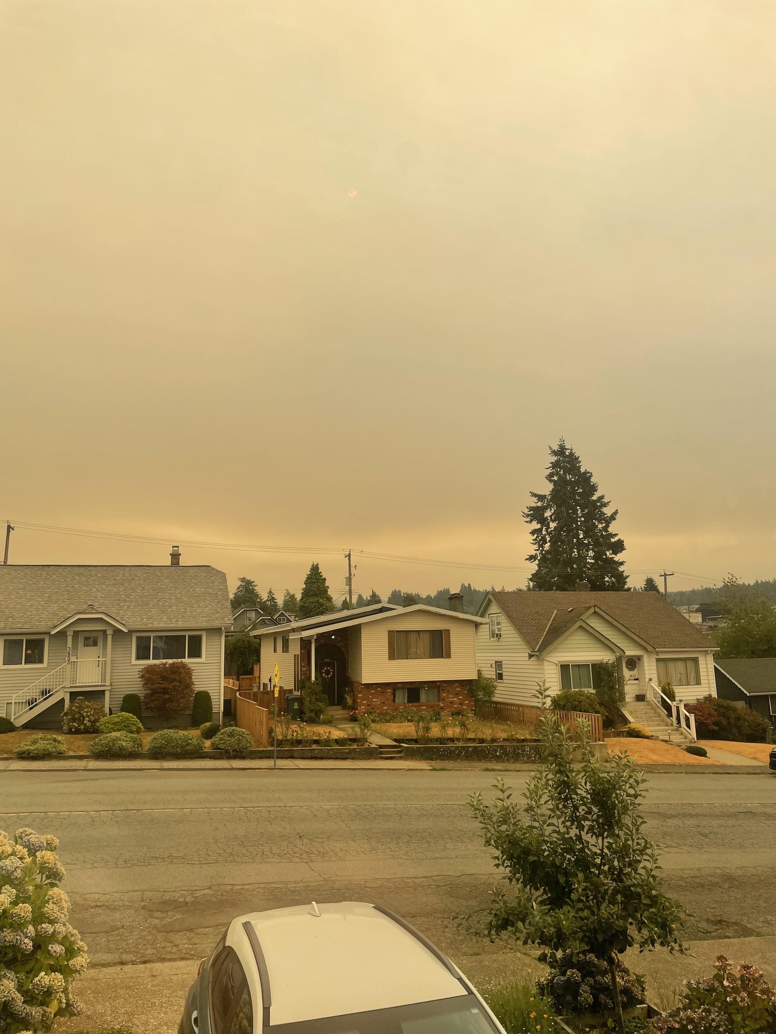
The smoke has really settled into the Valley overnight. Air Quality is very poor (click the image to go to the live page). If you can stay inside to avoid the smoke, that’s the best thing to do. Expect the smoke to stay as long as the calm wind persists. That said, there is strong wind in the forecast, so that might clear things out a little but it’s hard to say when those winds will arrive or if they will be in the right direction to do the trick.
That’s all for now. If I see a size and perimeter update I’ll include it here but lets hope this rain has kept things from growing too much today!
9:30 PM Aug 14 – 3400ha – Rain and Smoke are here.
The good news… very good news!… is that the rain has come on schedule and it means it!
the current satellite picture showing the cold front over southern Vancouver Island
There has not been a map or size update from BCWF since 11AM. The fire is now showing “moderate” behaviour but the rain won’t put it out. It will buy them time to contain it.
Weather Forecast
Expect light rain to continue through the night.
The first wave of rain ends Friday morning.
The second, stronger, wave of rain (see picture below) reaches the Island by Noon on Friday and continues into the evening.
After a break overnight, scattered showers will persist into Saturday.
We should stay mostly dry but cool through Sunday and into mid-week next week. Good for the fire!
Showing the strong rain front that is expected midday Friday
Smoke:
The gusty winds may return over the next few days, when it does, it will keep the smoke away, when the wind calms, the smoke will settle into the Valley.
Right now, the smoke is pretty bad. It’s not likely to get better until the fire is contained, which might be days, or weeks.
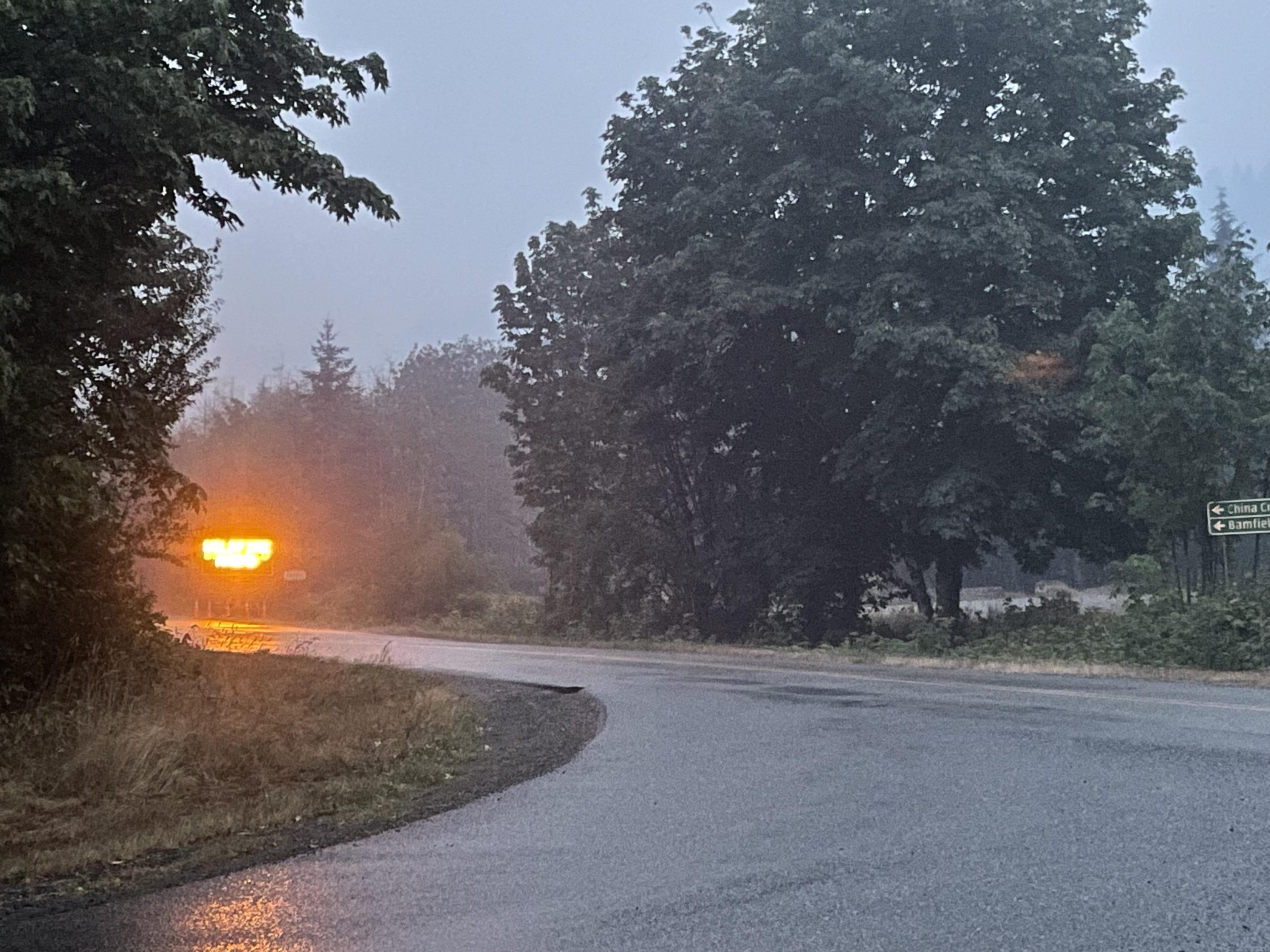
I was on that side of town this evening, so I took a picture from Anderson and Ship Creek Rd.
A picture from the corner of Anderson Avenue and Ship Creek road in Port Alberni on the evening of August 14, 2025
Take care out there.
12:00 PM Aug 14 – 3400ha – 5km from City – Advanced 2.7km on Wednesday.
The BCWF has updated as of 11:13AM August 13.
3406 hectares (34 square kilometres)
Fire lines being built on north and west sides to protect infrastructure and stop movement toward city.
Rain is not expected to stop fire but will ‘buy time’.
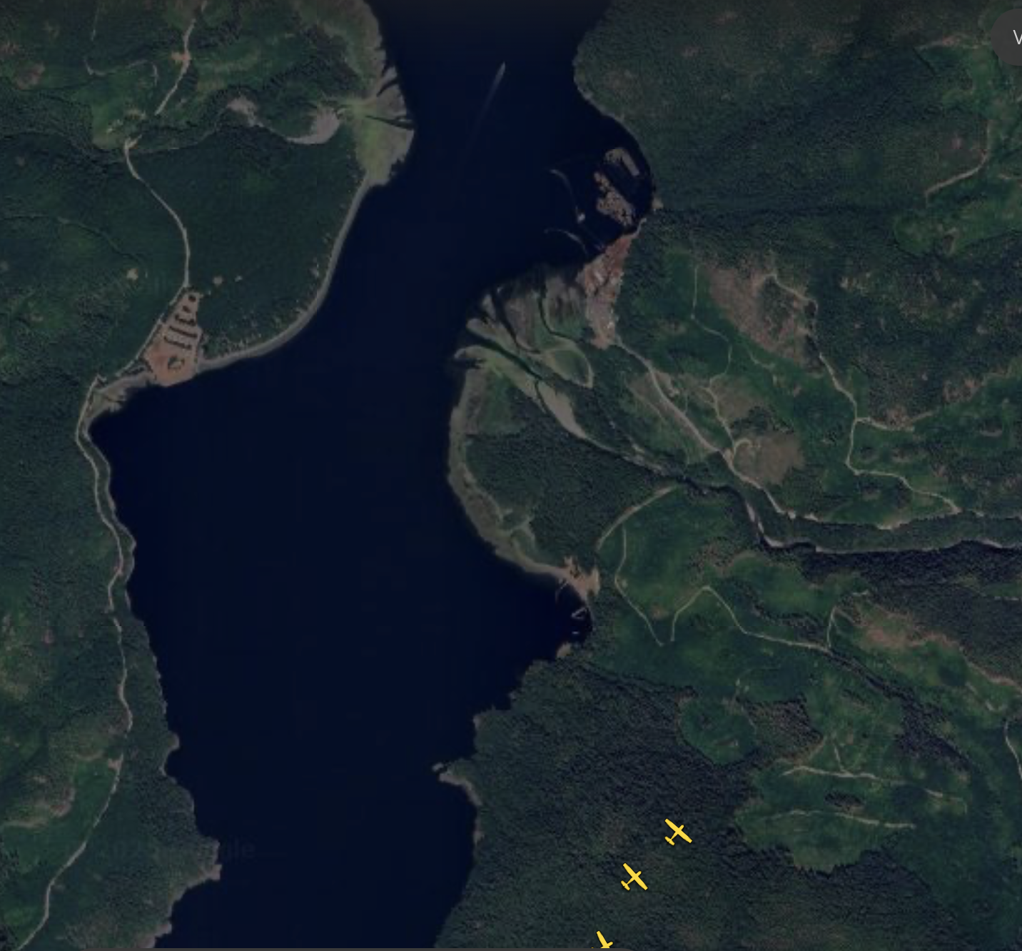
Here is the latest map and measurement from Anderson and Ship Creek Road in Port Alberni. Currently the fire is 5.7km from the edge of the City. That means it has moved about 2.7km closer to the City since yesterday at this time and 4km since the first day.
For those familiar with area, the closest edge of the fire is about 1.2km from the “Link Mill” site (heading to Bamfield, it’s the large cleared area a few turns after the road tuns to gravel)
It’s worth noting that if you go by the Satellite map I posted in the previous update, it makes the fire look like it is about 1-2km closer than it is. That is why we can’t use the Satellite as an exact measure.
BCWF has lots of crews working on the fire. The rain is not expected to fully suppress the fire but they are saying that it will buy them some time to build lines and defences to keep it from growing larger.
To all the firefighters and personnel out there, good luck and we are all rooting for you!
Take care everyone!
10:45AM – No BCWF size Update
There is still no update for the fire size or perimeter.
I friend on the open social media network Mastodon took the time to create this overlay of the BC Wildfire perimeters. There have been three major updates to the perimeter since the fire started. The order from oldest to newest is blue, red, and purple. The blue perimeter was released the morning of August 13 (Wednesday) and is what is currently shown.
The BC Wildfire service included this explanation their update this morning. (August 14):
“Fire perimeters are measured by helicopters flying the boundary or by crews walking it on the ground. This work can be affected by terrain or visibility. Currently, smoke is limiting our ability to obtain an accurate track of the fire perimeter. The fire size will be updated once accurate information is available from the field.“
We have to respect and trust that BC Wildfire is doing everything they can to ensure the safety of their crew and of our communities. That said, I believe 24 hours should be the absolute maximum time between perimeter or size estimate updates. Even if it is approximate and not exact, the public and decision makers need to have an understanding if there was growth toward the community or not.
Those satellite pictures are scary. But they don’t mean the fire is as close as it looks.
Understandably, people have been looking for other sources of information. A good and popular one is the NASA Fire Information Management System. Remember that they include this warning:
The warning/disclaimer screen that appears when you go to the NASA FIRMS website.
So when you see this image of the Underwood Fire, it does not mean that this is the actual size of the fire.
Screenshot from the NASA FIRMS tool shows newer detections in lighter shades of yellow.
A large amount of this area could be from the smoke itself or other anomalies. That is why I am not using this data to update my own maps or make estimates on the size of the fire. There are many tools in the toolbox, this is only one general view, and not the best for making precise decisions.
Now that there are actual clouds rolling in, this will decrease the accuracy of the satellite based tools even more.
Weather:
No big updates here. Though I did notice that the latest BCWF estimate is for rain to start around 5PM. I think this is a little too optimistic. There is a *very small* chance of showers this afternoon, but the main rain bands won’t reach the Island until 8-9PM tonight.
This is the current model picture it shows the rain approaching from 11AM this morning to midnight tonight.
It is currently 17ºC, which is a nice change from the past few days! If the smoke stays away we should reach 23ºC.
11:30PM – No BCWF update – New Weather Forecast.
The models just finished their evening update, so I thought I would do a forecast so it’s ready for folks to see in the morning. Everything else has not changed since the 9:00PM update below.
Thursday morning:
Low down to 13ºC – High Humidity.
Winds variable and light until noon.
Expect smokey air to stick around until the wind starts up, like Wednesday.
Thursday afternoon:
Inlet breeze will begins around noon. 5-10kph. As temperatures are lower, the wind should not rise as strongly as Wednesday.
High temperatures: 20-25ºC.
(Real) Clouds will begin to roll in around noon.
Isolated pockets of showers could begin in the 3PM hour particularly areas north of Port Alberni (Gold River, Campbell River)
Thursday evening to Friday morning:
Winds may calm later in the afternoon into evening.
First showers on Port Alberni/Fire pushed back to 11PM-1AM
Showers continue to 3AM-4AM then back off except on the extreme West Coast.
Friday:
Showers continue through the morning mostly focused on the extreme West Coast and the highlands of the mid-Island including near the Underwood fire area.
Generally Southerly winds should build through the morning as the final rain front approaches.
The final rain front with most intense rain is expected across the Island around noon to early afternoon.
Rain should continue to around 6PM then taper off. We dry out overnight on Friday.
Total 24hr rainfall between Thursday and Friday:
Port Alberni: 10-20mm
Underwood Fire: 20-50mm
Tofino/West Coast/Sutton Pass/Nitinat: 50-100mm
Saturday:
There are some scattered showers across the Island on Saturday. Nothing major, but hopefully some to continue helping the fire.
9:00PM – no new size – Expect smoke to settle in tonight.
There have been no new size updates. There was a minor map update earlier this evening that modified the boundaries of the fire. It is now about 8.2km from the edge of town. It is not considered to be threatening the City at this time.
Unless new information is released tonight, I will not update until Thursday morning.
The weather forecast remains the same. The wind should die down overnight. When it does, expect the smoke to settle into the Valley and Air Quality to worsen as a result. We may wake to a very dark morning, or, if the wind has already returned, it could clear again. Tomorrow will be much cooler, there should be southerly breeze, not as strong as today’s, that will last until the cold front and rain arrives on the Island around 5PM. Rain should start in Port Alberni around 8PM.
Photo taken at 8:21PM on August 13 shows the smoke starting to stretch over the City.
Take care out there.
3:00PM – 2156 hectares – Inlet Breeze is here – Intense rain on the way too.
Wildfire as of 2PM
Latest size was 2156 hectares at noon. No update since. The expectation is that it is actively growing. Look at the 10AM update for distance measurements. These will be out of date now.
Feel free to share the Youtube stream. It shows the plume of smoke, and the breeze. There is no sound. (the clicking is an artifact of the stream)
The weather is behaving (unfortunately) as expected last night.
We have strong south and southeast Alberni Inlet inflow winds. Gusting to 25-30kph.
Expect these winds to continue at least until sundown, possibly longer.
The clouds are also building as predicted along the Beaufort and Arrowsmith ranges. I don’t expect these to produce any rain but it is possible. Thunderstorms are not expected.
WednesdayOvernight to Thursday:
The wind should abate before midnight and become light and variable.
It will stay dry, but it will cool to 13 or 14ºC overnight. Humidity should be high. Above 80%.
Expect the smoke to return as the winds die down and the smoke settles.
Thursday:
Southerly winds will return first thing in the morning and likely build through the afternoon. This time, less due to heat and more due to the approaching cold front.
It will only get up to between 20-25ºC on Thursday.
Winds look like they will start as South or Southeast and thing turn to more Southerly or Southwest as the rain approaches the Island in the Afternoon.
Thursday night Rain — possibility for intense rain causing washouts in new fire-hit terrain.
The model is a little later for the rain than previously forecast.
The West Coast (Tofino/Ucluelet/Bamfield) to see showers first by 5PM.
Port Alberni and most of the rest of Vancouver Island has showers by 8PM or even as late last 11PM Thursday night.
24 hour totals between 5PM Thursday and 5PM Friday for parts of the West Coast and highlands are for 50-100mm of rain. This is good for knocking down the fire, but it could cause washouts anywhere there has been a recent fire.
Rainfall in Port Alberni appears to be in the 10-20mm rain.
Still a lot considering the length of our drought.
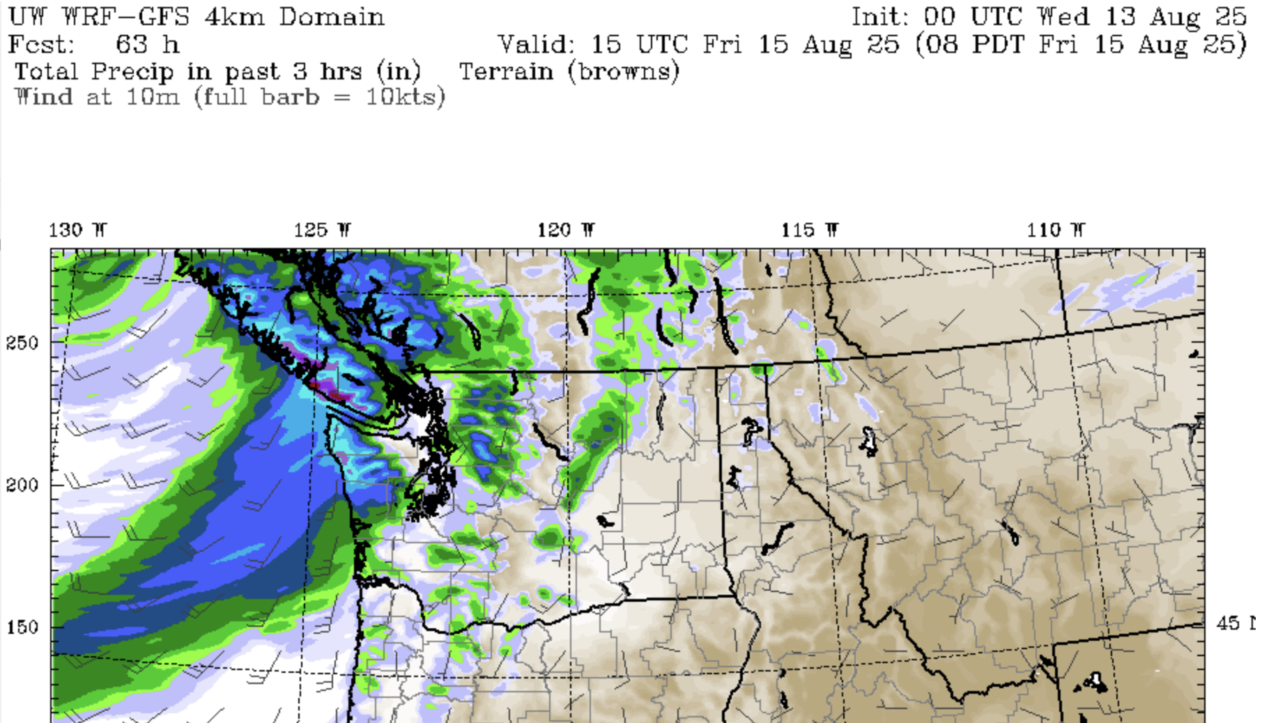
The image from the University of Washington model shows rainfall amounts of 3-5 inches (50-100mm) impacting the West Coast of Vancouver Island, especially the high elevations.
We are in a strange weather world my friends. Take care out there.
12:30PM – 2156 hectares – Bad Air Quality – Bad Alberni Inlet Breeze.
this is just a quick update. I am preparing my own house here at Alberniweather HQ.
The Alberni Inlet wind is here. Currently southeast, which will push the fire toward Town. There is no threat to the town yet and no change to the alert status.
Please stay alert. Monitor the ACRD website and app. Monitor BC wildfire. Tune in to The Peak radio station 93.3 FM.
Take care I will have an update later this afternoon.
A Ukrainian flag flies above Alberniweather HQ. It indicates south east winds. Time 12:15 PM.
10:00AM – 2036 hectares – High Smoke Ash fall – Chance it could “turn off” Inlet breeze.
The weather pattern has obviously changed now. If you’re not sure, look out the window and you’ll see the impact.
9:15 AM – A short comment on the “Unprecedented” nature (it is!) of the Underwood Fire. It is not normal, it is getting worse. It can and must be stopped. Please take this warning to heart and to your politicians.
Comment: In 2015 after the major (18 month) drought and 2014/15 Pacific “blob” (https://en.wikipedia.org/wiki/The_Blob_(Pacific_Ocean)) and subsequent massive 2015 BC fire season, there was a fire in Squamish (on the mainland) which is in the Coastal Fire Centre.
I was City councillor in Port Alberni at the time and at that year's UBCM conference for all municipal officials in the fall, after the fire season, we received a presentation from BC Wildfire on a Squamish "Elaho” fire. (2015 not 2024). It was over 15,000 hectares before it was finally contained.
According to the BC Wildfire service at that time, it was the first time they had seen Rank 4 and Rank 5 fire behaviour anywhere in the Coastal Fire Centre. It was unprecedented.
This was the 'new normal' of human-caused climate change.
Only the drought conditions and extreme heat could have caused the temperate rain forests of Coastal BC to exhibit this behaviour.
Now this ‘unprecedented' behaviour is in the temperate coastal rain forests of Vancouver Island. This is, and was, predictable.
This is climate change. The “new normal” is Change.
It is getting worse because *our* CO2/GHG emissions continue to rise.
The only way to stop this changing normal is to end the use of fossil fuels and stop the emissions of greenhouse gases immediately.
8:00AM Aug 13 – 1618ha – Evac Alert Cameron Heights
Important day. Weather is changing today. Stay vigilant. Watch ACRD Voyent and Web for new Alerts/Orders. Make preparations.
State of Local Emergency
Both the City of Port Alberni and the ACRD are in a State of Emergency. This means they are able to take special measures and ask for help from senior levels of government.
Evacuation Alerts and Orders remain the same as last night. (see ACRD webpage)
Fire now 1618 hectares (16.8 square kilometres)
Fire map has not updated. (see below for distance measurement of 8.6km)
Weather:
I will have a new Weather Forecast when models update around 11AM. Here is what has changed this morning:
Good News: “only” 28ºC high temperature for today. (down from 30) Heat Warning has ended.
BCWF Summit Main Weather station 5AM:16.8ºC, 78%, Wind Calm.
Good News: Relative Humidity is high this morning. 84% at Alberniweather, 93% at the Alberni Airport but it is lower near the fire as we see from the Summit Main station.
Concerning: Alberni Inlet Breeze (Southerly) expected to start at noon. This will push fire to the north.
Watch for: Possible cloud tower formation along Beaufort Range and Arrowsmith with possible showers. (see picture below) no chance of Thunderstorms/Lightning at this time. Rain will be minimal.
Watch for:Worsening Air Quality when winds shift to Alberni Inlet breeze/southerly. This will move more smoke into the Valley.
Possible Wildcard: One possibility today: If the smoke is already bad enough in the Valley that it blots the sun out, it might keep temperatures below 25ºC and the Alberni Inlet breeze might not start up or would be lesser. We saw this with the Dog Mountain fire.
The rest of the forecast remains the same as I posted last night. Rain arrives by 8PM Thursday.
Snapshot from last night’s model run shows precipitation Wednesday afternoon along the heights of the ranges on Central Vancouver Island. Also shows wind barb (just to the left of the Alberni Inlet) pointing south or southwest 5-10knot (10-20kph)
9:50PM Aug 12 – 1447ha – Evac alert Cameron Heights – New Weather Forecast
Check ACRD website link above for exact details and any changes. Also Voyent Alert App.
Evacuation Alert for Cameron Heights, adjacent Tseshaht Reserve, Ship Creek Road, Franklin River Road.
An Alert means you should be ready to leave at a moment’s notice.
An Order means you must leave.
As of 7:05PM BCWF update: Out of Control and 1447 hectares (14.47 square kilometres)
“The fire is displaying Rank 4 and Rank 5 fire behaviour.”
Even if you are not in an Alert area, you should be thinking about your preparations. Making plans to evacuate. Gathering supplies, gathering documents, bags etc. See the links at the top of the page for websites with tips.
Updated Weather Forecast
Tuesday Night:
Staying Warm through the Night – I am not confident that we will reach the predicted 15ºC low that Environment Canada is predicting. UWash model is predicting down to 17ºC.
Wind is looking OK: North or Northwest overnight until about 5AM then it looks iffy.
Wednesday Morning (5AM-12PM):
Looks like 15-17ºC as a low in the 2AM to 5AM hour.
Wind is difficult. Looks light, and variable. Could be swirling, north, or southwest.
Wednesday Afternoon (12PM-5PM)
Temperature will climb to 30ºC by 12-2PM.
UWash Model has the wind shift to moderate (10-15kph) South or Southwest by 11AM-12PM.
I believe we will see standard Alberni Inlet inflow winds on Wednesday afternoon. 10-20kph (5-10knot)
This could push the Fire line more toward the north and Port Alberni.
Wednesday Night (5PM-12AM)
Temperatures are expected to drop considerably – 10-15ºC or below.
The cold front reaches the Island around 8PM to 11PM.
There could be strong southerly winds (20kph+) overnight but the cool temperatures should help.
Thursday
Temperatures are much cooler – Only up to 23ºC.
Wind could still be strong up the Inlet southerly 20kph+
Using the current map (as of 10:20AM) the fire is now 8.6km from Anderson and Ship Creek. This is compared to 2PM when it was 9.2km and 11AM when it was 9.4km away.
As of 10:20PM the map from BC Wildfire shows the northern point of the fire has moved closer.
7:35PM Aug 12 – 1447ha – evacuation alert for Cameron Heights and adjacent Tseshaht reserve – I will update the weather forecast after 9PM
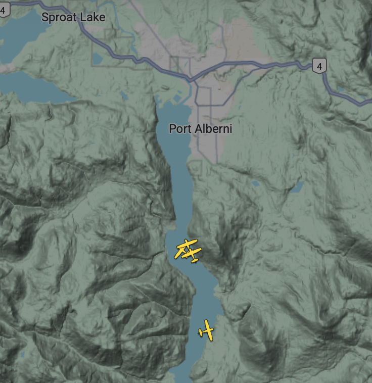
Squadron of 4 Fireboss skimmers now actioning the fire.
Looks like they are taking water from the Alberni Inlet.
It is not lost on ANYONE in Port Alberni that we are one day after the August 11 2024 anniversary of the Hawaii Mars water bomber being officially flown to a museum. The Phillipine Mars was sent to Arizona a few months later.
Looks like the main aerial attack effort is trying to protect the Franklin River log sort. This is south of the China Creek marina on the Alberni Inlet at the mouth of Franklin River. #bcwildfire#underwoodFire#portalberni
2:00PM August 12 – 9.2km away – heading up Franklin River?
Update on distance from Anderson Ave. and Ship Creek Rd.
Screenshot at 2PM of the BCWF map shows the straight distance from Anderson and Ship Creek to the closest point of the fire perimeter.The fire perimeter appears to be growing to the east moving along the Franklin River
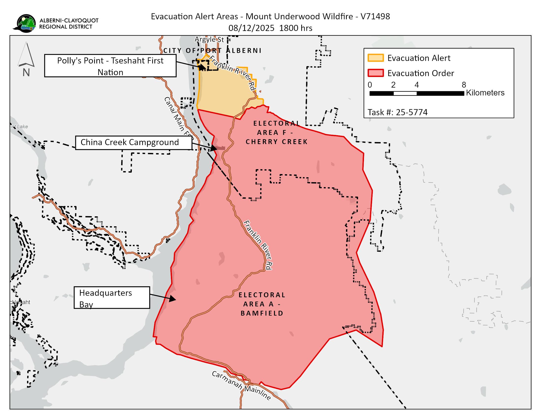
It now lists the official evacuation order for the area of China Creek Campground and alon the Bamfield road. Most if not all of these places were evacuated last night.
Evacuation order as of 10:30AM Tuesday August 12 2025
This is the website you will want to monitor for updates on evacuation alerts and orders.
There are no further updates on the fire from BCWF at this time. It is already over 36ºC. Stay safe out there.
11:20AM August 12 – 859 hectares – New Weather Forecast
the underwood fire at 10:40AM. Taken from 6th and Redford in Port Alberni. Looking southeast.
MOUNT UNDERWOOD WILDFIRE UPDATE #2 – August 12, 2025 at 8:40 a.m.
BC Wildfire is actively engaged and has deployed resources, with three unit crews mobilized and more on the way. Please avoid the area. The Emergency Operations Centre is continuing to monitor the situation. We will provide further updates as they become available. A 24-hour reception centre was set up last night at the Alberni Athletic Hall and campers from the China Creek Campground were invited to camp overnight at the Fall Fair grounds.
There are no evacuation alerts or orders at this time.
The power is out in the Bamfield and Anacla areas, and it is expected that the outage will last at least 72 hours. Visitors to the area should take this outage into consideration and residents should prepare for an extended power outage.
BCWF update
Latest BCWF update for 11:30AM. The fire is now 859 hectares (8.5 square kilometres). The good news is it is mostly on the east side of the Bamfield road and it has not moved north significantly toward Port Alberni and is not on the west/Inlet side of the road. Unless you are a resident, do not attempt to travel to Bamfield.
It is still more than 9km away from Port Alberni (corner of Anderson and Ship Creek.
Tough 1-2 day Weather Forecast – Positive for Thursday evening.
As of about 10:45AM when this picture was taken, the wind appears to be moving the smoke to the East and South. This is a little different from yesterday afternoon, but still good for populated areas hopefully. People in Nanaimo and Coombs may receive some smoke.
Now is the time to prepare your property and your family in case you need to evacuate. Use the links at the top of the page for information on how to be fire smart, how to make a Grab and Go Bag, and how to prepare your home.
Tuesday: Winds remain mostly northerly and northwesterly. The wind could shift to light southerly or southwesterly in the 5PM timeframe. Temperatures are already over 30ºC and will climb to 37ºC and feel like 40. Humidity is likely to be less than 30% near the fire.
Wednesday: This will be mostly the same, but a little cooler. Temperature to 30ºC and feel like 32. The fire will should still be mostly moving away from Port Alberni but there is a chance we see the wind shift to the south a little early. This is hard to predict as it is a change over in weather pattern but we should be vigilant and aware especially in the afternoon because it will still be hot enough for very strong fire behaviour.
Thursday: Winds are expected to turn to the South/Southwest in late morning or noon. This could potentially push the fire toward Port Alberni. Rain is expected to get to the Island by evening on Thursday. However, that leaves the entire day. We will have south to southeasterly winds starting in the morning Thursday. This could push the fire toward Port Alberni.
The rain arrives on the Island after 5PM on Thursday according to the current University of Washington forecast model. Let’s hope it is a lot!
I have added a distance measurement from the corner of Anderson Avenue and Ship Creek Road: 9.8km
The map shows that the fire moved about 4.5km yesterday, so if the wind was in the opposite direction, it would probably be about 5 or 6km from the edge of town today. We got very lucky. Let’s hope that luck stays and fire crews can build some lines around it today. Stay safe out there, and be prepared.
9:00AM August 12 – BCWF small update – waiting for more.
BCWF updated their page at 8:50AM but only very limited new info. Size is still 630ha but that will be more now.
They have updated the response text but there is no new guidance or maps. The ACRD Voyent App also has not updated yet this morning.
Obviously we are all waiting for more information. BCWF will be very busy getting the details the public needs. Remember to be patient with them.
I am also waiting for the morning weather model updates from the University of Washington forecast page. The medium resolution (4KM) forecast should be available before 10AM so I will make a new weather forecast around 10:30 or 11AM. Until then, the current Environment Canada and my comments at 10PM last night are all valid. Wind is expected to continue from the NNW, pushing the fire away from Port Alberni. Small chance of a shift to south/southwest winds later this afternoon.
That said, even though the wind might be pushing it away… the fire is very large and could still grow in this direction. Be Prepared to evacuate. Make a grab and go bag. Get your plans, your family, your home ready in case the fire changes direction or grows more quickly.
Some simple math to give an idea of size and distance of the fire compared to Port Alberni
As of 10PM the fire covers an area of 630 hectares or 6.3 square kilometres.
The City of Port Alberni covers an area 20 square kilometres, or 2000 hectares. (StatsCan)
So in just 4 hours yesterday, the fire grew to nearly half the size of the City of Port Alberni.
As I mentioned last night, the fire point on the BCWF map is about 10km from Anderson Road and Ship Creek Road.
Imagine the fire is in a box 6km by 6km. If the wind had been blowing toward Port Alberni, the fire could be within just 4km of Port Alberni by now.
If you would like to see when the fire started, there is a Youtube video of the timelapse at the 12AM update below.
Go to the Alberniweather Youtube channel for the live stream, or the timelapse. I will probably upload more Timelapses there today if I get time.
No update from the ACRD Voyent Alert app as of 8AM
No update from BCWildfire as of 8AM – still listed as 630 hectares, but should expect it to already be larger.
If you live in the City of Port Alberni or anywhere in the Alberni Valley, the time to prepare is now.
The Fire grew to 630 hectares or 6.3 square kilometres.
The City of Port Alberni covers an area of about 2000 hectares or 20 square kilometres (StatsCan). So the fire covers an area just under half the entire area of the City of Port Alberni. Had the wind been blowing from the southwest yesterday afternoon, as it often does in the summer, the fire would likely already be at the edge of or in town.
The weather forecast remains the same (see 10PM update)
Unfortunately the conditions were already warming and drying as of the 6AM update now available from the Summit Station but the wind remains in a good direction away from town: NNW.
Latest BCWF Summit Main Weather Station Conditions: As of 6:00AM Temp: 23.7°C RH: 38% Wind: NNW 5.7km/h
With these conditions, expect the fire to grow very fast.
Just finished weed eating the yard and mowing the lawn. Next! Clean up any and all fire-fuel!
I will update this post again at 8AM unless something major happens sooner. Keep an eye on ACRD Voyent Alert and BCWF and listen to the Peak radio 93.3FM.
There have not been any updates to the ACRD Voyent App or to B.C. Wildfire as of 6AM.
The smoke seems to have lessened a little but is still visible.
Snapshot from the webcam at 5:39AM Aug 12
The wind is still mainly from the NNW pushing the fire mostly away from Port Alberni. However, it did not cool below 20°C here in Port Alberni nor toward Bamfield. There is a weather station at Summit Main near Franklin River.
Latest BCWF Summit Main Weather Station Conditions: As of 3:00AM Temp: 22.5°C RH: 48% Wind: NNW 6.5km/h
This station is near Franklin River on the Bamfield/Nitinat road.
The weather forecast has not changed. My 10PM weather forecast remains valid. Today should remain mostly Northerly winds but there is a chance the wind will turn to the south/southwest by 5PM. It will be very hot and dry.
What I am doing today – Preparing
Today is the day to prepare to evacuate. We hopefully have until the weather pattern/wind shifts Wednesday before things could change for the worse. Hopefully no one will need to other than the China Creek folks who already have, but now is our chance to be ready. Consider fire proofing your outside home and property. Have sprinklers set up, get rid of flammable stuff in the yard. Clean up so firefighters can access your property easily if needed.
12:00AM August 12 – Shining brightly from Port Alberni but not over the ridge.
10:40PM ACRD update from Voyent Alert:
“The Mount Underwood Wildfire is currently listed at 630 Hectares in size and classified as Out of Control. BC Wildfire is actively engaged and has deployed resources. Please avoid the area. The Bamfield Road is closed.”
“Campers from China Creek are being directed to the Fall Fair Grounds, by way of the Alberni Valley Multiplex parking lot.”
Anyone evacuated from the Mount Underwood Wildfire should head to the reception centre at the Alberni Athletic Hall (3727 Roger St. Port Alberni), which will be set up soon.
Other information from Alberniweather (Chris):
Currently 630ha (Aug 11 – 10:18PM update) – It is a Rank 4 or 5 fire according to BCWF – very vigorous and dangerous.
Latest BCWF Summit Weather Station Conditions: 10PM Temp: 24.2° C RH: 38% Wind: NNW 7.4 km/h A BC Wildfire Weather station is at Summit Main – Data is delayed but viewable on the BCWildfire page by clicking on the map near the Underwood Fire symbol.
There has been a helicopter watching the fire in the past hour.
I have updated the critical links above, check them all out.
The wind has mostly died down, which is good. But when it is there, it does still seem to be mainly southerly/southwesterly, which is not good.
The weather forecast I made below at 10PM still applies.
I measured the distance on the BC Wildfire map from Anderson and Ship Creek roads to the fire point on the map. Distance is just over 10km but the actual firefront could be closer than that. BCWildfire will provide a more precise perimeter in the morning so we will have a better idea then.
Here is a slow timelapse of the start of the fire as seen from the Alberniweather webcam. The first smoke appears above the ridge at about 6:43PM. Images are at 1 minute intervals.
10PM – ACRD opens Emergency Operations. – I will focus on the weather forecast.
The main information will come from the Alberni Clayoquot Regional District, see the link at the top of this post. I am going to focus on what I can help with, so here’s the weather forecast.
Monday Night Forecast – Light South Winds currently. Not Good for Fire or Smoke.
Wind is everything. The wind just shifted to the South in the past few minutes. (9:25PM) Be alert. Make a grab and go bag right now if you are on the south side of Port Alberni and it is not a bad idea for anyone. Current winds as of writing are light, 5kph from the Southwest (SW).
The forecast is for light northerly winds overnight. This is good. But considering the wind is southerly right now, this may push the fire toward the Alberni Valley anyway.
Tuesday Forecast – Hot – Wind Shifting to South in Afternoon
It remains very hot tomorrow though if we have smoke cover it might feel less hot.
The wind forecast is still for northerly winds in the morning but wind shifts to Southerly/SW in the 2-5PM period. This is critical.
Wednesday Forecast – Less Hot but Southerly Winds in Late Morning – Afternoon
Wednesday shift back to normal patterns with slightly less heat, but it looks like we will have our normal afternoon southerly inflow winds up the inlet which will push the fire toward Port Alberni
Initial post: 7PM – I have no official info. Looks like it is near China Creek?
Only good news is the wind is blowing from North, away from town.
Keep locked on BC Wildfire page. Link is on the Homepage.
I will update my socialbc feed as I find out more.