Last nights beautiful clear and cold break has set us up nicely for, I think, a bit of “Strait Effect” snow.
Update There is a Snowfall warming for East Coast of Vancouver Island, up to 15cm of snow tonight through tomorrow.
Over the next 24 hours a low is going to develop off of the West Coast of the Island and gradually move south. This will pull cold air out of the Interior, and across the Strait of Georgia.
BC Highway cam at Black Creek shows there has already been some snow fall there (north of Courtenay).
As the low develops and deepens a little the winds should become a little more persistent from the North and North East, drag over the air across the Strait, pick up moisture, and dump it onto the East Coast.
Whether Port Alberni gets any of that remains to be seen. EC is calling for 5-10cm. But personally I would say the East Coast is more likely to get the high end of that and we are more likely to get the low end. Sometimes we are included in the Strait effect stuff, other times the Beauforts act as a pretty effective block and we just get the cold air pouring over the Comox glacier instead. Most likely spots for significant accumulations will be from Cameron Lake to Coombs with possibly Parksville and Nanaimo as well.
Most likely times for heaviest snowfall should be early-mid Friday morning… the key will be whether it stays cold enough for snow. The Canadian model doesn’t think so. The GFS does… we’ll see who wins.
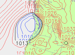
Here is the Canadian forecast model for 7AM Friday morning. Notice the low right off of the Island, headed south, with tight isobars on the North East side which should draw some moderate winds over the Strait.


Comments
21 responses to ““Strait Effect” snow on the way”
This surprises me a bit – I wasn’t expecting the outflow winds bringing strait effect snow, Bring it on!
It is partly cloudy, high cloud, with whisps of clear sky here in Nanaimo. However there are very impressive, billowy clouds building in the middle of the Strait. Quite a jolly line of them stretching from Texada south towards Vancouver. Perhaps harbingers of what’s to come 🙂
Just started snowing in North Cowichan. Coming down pretty hard but not sure how long it will last, looks like some hit and miss showers today, especially during the early part of the day. I am also a little surprised by the straight effect snow forecast. We usually need some real arctic air to really get the straight fired up. Its the temperature contrast between ocean and air that helps increase the snowfall amounts. My guess would be that the atmosphere is unstable enough that it is only going to take some marginally cold air to create the snow.
Holy Crap, it’s a blizzard in Port!
I’m at my office downtown PA and 10 minutes ago it started snowing very heavily. No webcam on the Hump right now, but it looks like Cowichan is the only other place with snow!
There is a very grey cloud moving in from the West over Nanaimo…. it’s a cloud that hollers *snow*.
Wow look at the harbour webcam!
Plows just going up the hump now, other than that people seem to be driving with extreme caution.
Snowing lightly at VIU now.
UPDATE: The Hump is a nightmare! people are stopping in to the Visitor Centre and telling me that vehicles are all over the place. Sutton Pass is likely worse. Please don’t go over if you can help it. You will be stuck for a while…..Be safe!
The camera does indeed look like a nightmare up there 😐
Snowing heavily and very busy.
All I’m seeing is south and south east winds over the strait, temps between 3 and 5 degrees near the water. We are going to need those winds to switch to the east and northeast to get any strait effect happening
well ‘strait effect’ or not doesn’t change the fact that there is snow on the ground in Port, and that the hump is closed
You’re right Chris, and it still looks really ugly up there. In hindsight though, I think this wasn’t strait effect at all, but just part of that slowwly moving low sliding down the coast.
Indeed… slow it has been… and this was by no means part of the forecast!
Ya certainly wasn’t expecting all this…. the hump is a disaster right now.
And it looks according to the Satellite picture like there is a bit more moisture ready to push in off the west coast before the low finally moves south and the winds shift.
Quite a day!
Yeesh, it seems to be making people reeeally testy!
I’m all smiles Eve, and I can’t wait for tomorrow!
Me too Bill B, what’s up for tomorrow? The wind just changed direction and it is snowing again…..from the North.
Who knows? That’s why it’s so much fun! Environment Canada says 5-10 cm overnight, but the GFS looks like there isn’t much more precip coming and it’ll all be over by 7 or 8 in the morning.
sounds like the hump is open now