
The threat of snow is receding slightly for the weekend as temperatures warm up just enough to make a difference. That means rain, and a fair amount of it, between today and Monday. It could still flip flop and end up with snow on Sunday but that is looking less likely now. We will just have to see.
There is chatter however of another shift of the larger North American pattern. The big dip in the jet stream allowing Arctic air to flood into Eastern Canada is going to start shifting west a bit and so might allow some of that Arctic air to come our way around Thursday. It’s a ways out.., but we will have to see what happens. Here is the view from Brett Anderson’s blog yesterday:
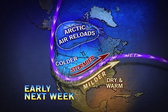
Once the Arctic Air has ‘recharged ‘ as he puts it, then the models have it heading back East to deliver more frigid weather to that part of the Continent and milder, wetter time for us.
Now it is nothing new that it gets cold in Canada. However, as you’ve heard here before, new research is showing that the loss of Arctic sea ice is causing unusually warm conditions in the Arctic which translates to unusually long spells of snowy weather in Eastern North America (note I did not say record cold)
This is due to changes in the upper Stratosphere where in the winter the Arctic vortex which generally looks like this: 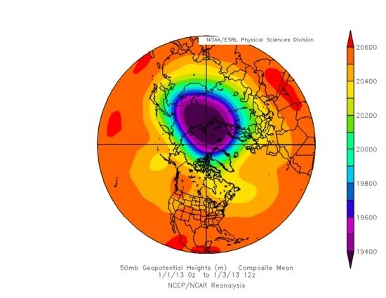
(Image from late December of Stratosphere temperature anomaly)
…. bottling cold air up there, now more often looks like this:
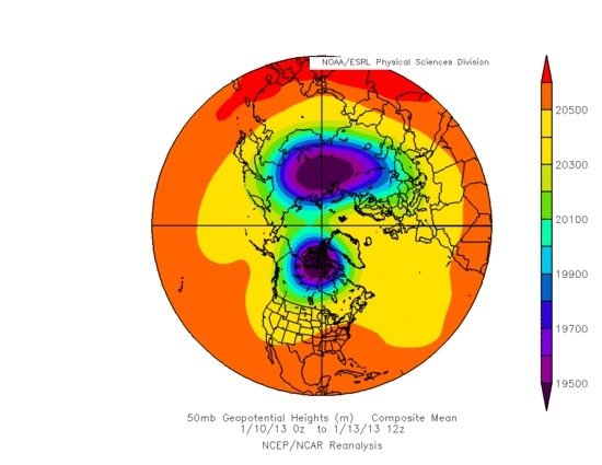
(Image from January of Stratosphere temperature anomaly)
As you can see the vortex has broken down, split in two and allowed warmth to flood into the Arctic and Cold to dive down into the Continents. This is being coined as the “Warm Arctic, Cold Continents” phenomenon.
Why? Well perhaps its due to the extremely thin ice?

Even at the North Pole itself, this imagery shows the ice is less than 2 metres thick. That means it is likely first or second year ice. The only old, and thick ice more than 4 or 5 metres thick is stuck along the islands of the Canadian Arctic Archipelago… and it is slowly being whittled away.
Here is an animation showing how thickness has declined, even through seasonal variations, over the past 30 years.
If the Arctic continues to lose ice volume and area at current rates, it will likely be ice free (or just a bunch of broken up slush) by September 2014 or 2015. August and October could fall as soon as 2018. These are massive changes in the amount of heat energy absorbed by our planet through the Arctic.
The effect on the weather ‘down here‘ will not be small.
(Thanks goes to Linda Brown for alerting me to recent discussion on the Arctic Sea Ice blog about the current sad, and frighteningly bad, state of the Arctic as we set up for another melt season. The posts and comments there are simultaneously fascinating, informative and disturbing and you can literally spend hours going through all of the research and data they post)