
Well it’s hard to deny it anymore, and indeed, the weather forecasters are now starting to apologize… Why? Because this winter has really been nothing like what they (yours truly included) were predicting in those breathless forecasts back in October and November.
Both Environment Canada and Accuweather.com were predicting a very cold winter for Western Canada in particular, but so far, only us on the extreme West Coast have got anywhere near that prediction. Alberta, Saskatchewan and Manitoba have all had record warmth even allowing grass fires to spread! BC has been closer to normal.
I’ve dug up some numbers using the Climate Normals from EC for Port Alberni and my own station records, I’ve also included numbers from last winter to compare.
December Mean Temperatures:
Normal: 2.5C
2011: 1.9C
2010: 2.7C
January Mean Temperatures:
Normal: 2.1C
2012: 1.8C
2011: 2.3C
So as you can see we have been cooler than normal, but not hugely so.
Digging a little deeper, I find this a little more interesting, look at the differences in Average Minimum and Maximum daily temperatures.
December Mean Min/Max Temperatures:
Normal: 0.2C/4.7C
2011: 0.3C/3.8C
2010:1.0C/5.3C
January Mean Min/Max Temperatures:
Normal: -0.5C/4.6C
2012: -0.6C/4.9C
2011:0.2C/4.6C
Did you see it? The average minimum temperatures have been right at normal (December was .1 above Jan .1 below), it’s the daily maximums that have been colder than normal. This demonstrates nicely that even though it felt somewhat colder, we just never got that big shot of super cold weather that was being predicted back in the fall.
So now the question is why. It’s not unusual for super long term forecasts to be a crap shoot, but, modeling has generally gotten good enough that this kind of a miss is just not acceptable.
It seems like the Arctic has again thrown us a curve ball.. Brett Anderson explained it best yesterday.
A near record strong, unusually long duration, positive phase of the Arctic Oscillation from December through early January allowed a strong westerly flow of air off the Pacific to dominate, cutting off the Arctic air to the north. Our original forecast for the winter in this region was based on strong analog and computer model consensus. Ocean water temperatures, the cold PDO and La Nina were also factored in, but it seems that the positive AO basically overwhelmed most of the other variables.
Now consider that last year we heard the same story about 2010s winter forecast… I mentioned a post by Dr. Jeff Masters on his evalution of the 2010 winter and outlook for 2011, it may be cause for pause.
About the 2010 winter forecast he said :
The reason for [the 2010 US Winter Forecast] failure was that it only took into account the impacts of La Niña on the weather–and not the Arctic Oscillation (AO), and its close cousin, the North Atlantic Oscillation (NAO.)
Sound familiar?
It appears that once again, we have got the Arctic Oscillation wrong and it has produced much different climate conditions than we would otherwise expect.
In that rather prescient post, Dr. Masters also notes:
The North Atlantic Oscillation (NAO) is a climate pattern in the North Atlantic Ocean of fluctuations in the difference of sea-level pressure between the Icelandic Low and the Azores High. It is one of oldest known climate oscillations–seafaring Scandinavians described the pattern several centuries ago.
It should be noted that the NAO is a close cousin of the Arctic Oscillation (AO), and can be thought of as the North Atlantic component of the larger-scale Arctic Oscillation. Since the AO is a larger-scale pattern, scientists refer to the AO instead of the NAO when discussing large-scale winter circulation patterns.
Unfortunately, the AO is not predictable more than about two weeks in advance. Thus, the latest NOAA winter forecast warns: “The evolving La Niña will shape this winter,” said Mike Halpert, deputy director of NOAA’s Climate Prediction Center. “There is a wild card, though. The erratic Arctic Oscillation can generate strong shifts in the climate patterns that could overwhelm or amplify La Niña’s typical impacts.”
Looks like we drew the wild card.
But of course, this is science, so there is always an explanation. The question everyone will be asking is, is it related to Climate Change… Recent research suggests links between recent changes in Arctic Oscillation patterns and new stored heat from record low Arctic sea ice levels… But not quite in the way we’ve seen this year. Clearly, more research is needed.
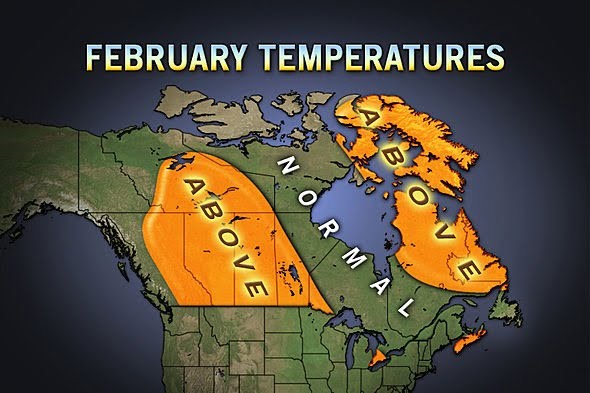
Finally, of course, we have one more month (meteorologically speaking) of winter to go and so we could very well get a shot of cold and snow. As you can see in the graphic below, one thing is for sure, it won’t save the cold winter forecast of 2011.
Comments
4 responses to “Long Term Winter Forecast Bombs.”
Its funny you put this up today as I was just talking to my wife about the 2011/12 deep freeze that wasn’t just this morning. Its nice that we have seen the occasional sunny day this winter too!
Ya, it’s been better in January… but I think in terms of fog it has actually been more foggy than normal, even for us! 🙂
The much narrowed-difference between daily low and daily high with the highs taking the biggest hit is an indication of that.
That said, I think February is going to be quite pleasant 🙂
Thanks for the research Chris – I woke up this morning with just this analysis in mind, and it confirms my thoughts on the winter. I suspect that if you compared the EC normals with temps at their own weather station, rather than yours, it would knock our January temps down another notch or two.