Forecast remains dry through weekend – Arctic Ice shrinks

The forecast has not changed. We will remain dry through the weekend. It will cool slightly to temperatures below 30°C but still remain very pleasant.
The fire danger remains at High and is expected to stay there for the forseeable future.
Arctic Ice Drops to 2nd Lowest.
After a couple years of recovery after its massive drop in 2012, this years Arctic melt season has been on a steady trip downward and current levels are now trending below the “recovery” levels, though still well above the historic 2012 melt season. The chart below is from the latest monthly report from the National Snow and Ice Data Centre at the University of Colorado which is the main headquarters for world ice research in the US. http://nsidc.org/arcticseaicenews/

Main points from the latest report are that the NorthEast Arctic sea passage over Russia is open once again. It opened for the first time in history just a few years ago and has been open most years since. The Canadian northwest passage with its tight island bound entrances has not opened this year but the southern “Amundsen” route may be passable.

The long term decline in seasonal Arctic ice continues. The graph below shows the September minimum as it marches toward zero at 13.3% per decade.
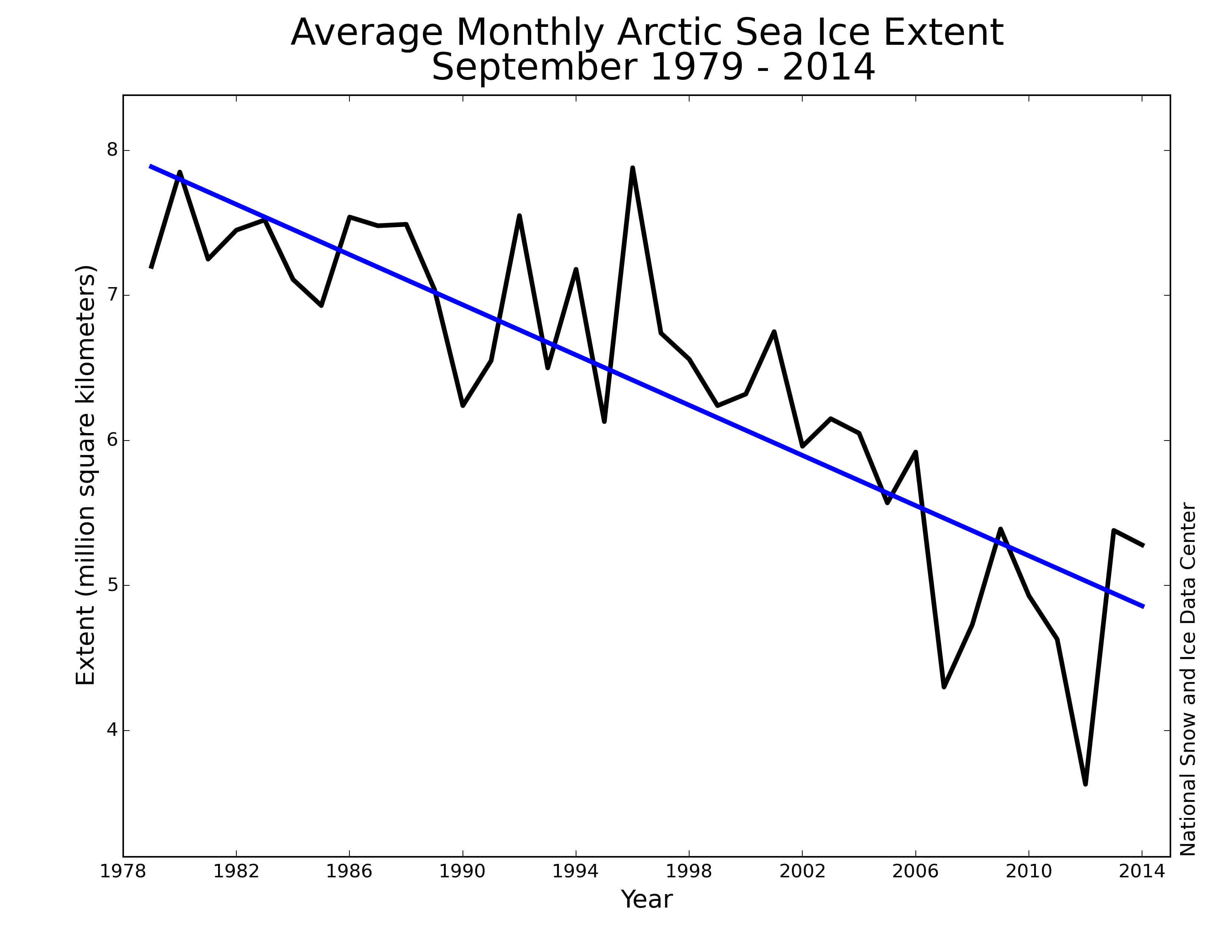 With current September minimums at arounf 5 million square kilometres, following that linear 13.3% decline would mean it would take many decades to reach zero. However, as we can see with the spikes downward in 2007 and again 2012, every once in a while, the Arctic can react very quickly. Dropping more than 20% in one year.
And we haven’t even started talking about El Niño… or the “blob”. More on those in a future post.


“And we haven’t even started talking about El Niño… or the “blob”.
Curious as to why no mention of the PDO. And it’s not just you, despite the importance of a shift in the PDO phase from negative to positive, there is almost no mention of the
implications on popular weather/climate sites. Given that the same winds that
bring atmospheric rivers from Hawaii to BC blow across the area covered by the
PDO, these above average SSTs will have (are having) an impact on BC. The could
potentially do so for decades as they have in the past.
Look at the values here from Jan 2014 on
http://research.jisao.washington.edu/pdo/PDO.latest
Given that this will impact farming, fishing, logging and other important BC industries and
livelihoods, I would have assumed that the meteorology community would be
saying something like, “The positive PDO phase means warmer, drier conditions
(evapotranspiration) in BC for some years to come regardless of human caused climate
change.” Yet they are saying nothing about this. Kevin Trenberth is one of the
few who is but like most of those who speak on this issue he does so in regard
to “the global warming pause”, not immediate socioeconomic impacts.
I’d be interested to hear any thoughts you have with regard to the PDO.
What is pdo and sst? Sounds interesting.
Pacific Decadal Oscillation and Sea Surface Temperature and I do indeed intend to address both in my monthly update at the start of September. 🙂
No doubt there’s been an epic shift in ocean weather patterns and Temps. I’m betting the ‘blob’ beats godzilla because the blob is cornered. ..where’s it gonna go? Fasten your seat belts for weather this fall 🙂
‘May you live in interesting times’, Chinese proverb that is coming true far too often in my life.