UPDATED – 11:30AM: Forecast Flip – But Will It Help?
UPDATED 11:30AM: As I thought might happen, the forecast has swung back to a much drier outlook. Only a trace of rain likely on Tuesday now and only 4mm by Wednesday afternoon. I’ve updated the post with images from this mornings run compared to the originals from last night.
This remains a low confidence forecast.
Summary: The short term forecast has changed drastically in the past 48 hours. However, for our specific region in the Alberni Valley we may not get as much or any rain like other areas of around the East and South Coast of the Island and Lower Mainland.
So when you hear today on the news that a “change in the weather” is happening take it with a grain of salt. Yes it will be cloudier and cooler. But the drought is unlikely to be truly broken with only 8mm 4 mm predicted between now and Wednesday afternoon.
It is still going to be very hot today (we set a short term record for the day yesterday reaching 35.0ºC officially at the Airport). It is still going to get up to almost 30ºC and considering the threat of rain, it may feel pretty humid Tuesday and Wednesday.
Details: As of just a couple days ago, all the models and forecasts were predicting zero rain. The UWash models had little to no chance of precipitation anywhere on the Island for the next week or more and the Canadian Ensemble looked like this:
Now the Canadian Ensemble looks like this:
The unusual part isn’t so much that the forecast changed, forecasts always change. The strange thing is that the forecast changed so drastically in the *short* term. These days, any forecast within 3 days is very nearly certain except for the minutia.
However, take a look the graphs above again. The consensus (red line) isn’t exactly pouring on the water. Anywhere between 0 and 20 mm of rain is predicted with models predicting earlier Tuesday rain going higher than models predicting the precipitation to occur later Tuesday.
And in the long term beyond a week (which is where we expect changes in the forecast to happen) the forecast is actually much drier than it was a couple days ago.
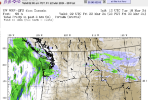
The UWash models are less optimistic for rain in our immediate vicinity, focusing more on the East Coast and Victoria/Vancouver areas.
Last nights run has a band of showers quickly moving up from the South (unusual) Tuesday morning between 8 and 11AM.

This mornings run has it a lot drier, with not much escaping northwest Washington.

A slightly more intense band will possibly cross Wednesday morning. But I would not put a lot of stock in that just yet since the forecast has been so changeable.
Overall, the image below shows that over 72 hours (3 days) between sunday and wednesday afternoon the Alberni Valley will only get 8mm (0.32in) of rain.
Certainly not enough to quench the thirst of my browning weeping birch in our backyard!
This mornings run pulls the precipitation back into Washington as it did with the Tuesday precipitation. I doubt very much this will aleviate our fire danger or drought concerns.


Interesting flip! I was looking at the different models on SpotWx yesterday and there was only 1 (can’t remember which) that had any precipitation at all, so I agree with you that it’s going to be very little, if any. But we won’t really know ’til we get there!
For sure. This mornings model will be one to watch for sure. Since it seems to be coming up from the south it might be interesting to see if the Olympic mountains impart any influence on the situation.
In fact looking at the models that have already updated courtesy spotwx.com, they are basically all over the place in terms of precipitation. They are all consistent on temperature though.