Flood Watch in Port Alberni and most of the South Coast

Rain began around 5AM this morning
We are into Flood Watches now from the BC River Forecast Centre.

Here is the current message from BCRFC:
Rivers are expected to see rises through Saturday and overnight into Sunday. Current precipitation forecasts and hydrologic modelling and assessments are indicating the potential for flooding in areas around the south half of Vancouver Island (south of Campbell River and Gold River) with most focused rainfall around Port Renfrew through to Cowichan Lake and the Sooke River watershed.
Spillover across the Vancouver Island ranges is possible, and with the potential for flood flows onto the eastern slopes of Vancouver Island, including the Koksilah River, Chemainus River, Cowichan River, Englishman River and surrounding areas. On North Vancouver Island and the Central Coast, high streamflow is expected due to more moderate rainfalls.
We’ve received 25mm so far at Alberniweather. This morning’s forecast expects 30-40mm total in Port Alberni by Sunday morning. The West of the Island, Cowichan Valley and Fraser Valley will see closer to 100mm or more.


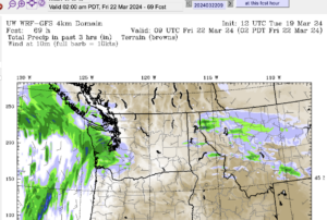
The bottom image shows from 4AM Sunday to Morning another 15-20mm is in store for Port Alberni and 40mm or more in the Fraser Valley. Hopefully these aren’t catastrophic amounts.
We’ll get a decent break on Monday but there will be some showers in the region and the next Atmospheric River will come ashore overnight Monday into Tuesday morning.
Keep an eye on the City of Port Alberni and ACRD twitter and Facebook pages for the latest. There are sandbags available at City Works and the Sproat Lake Fire Hall on Highway 4.


