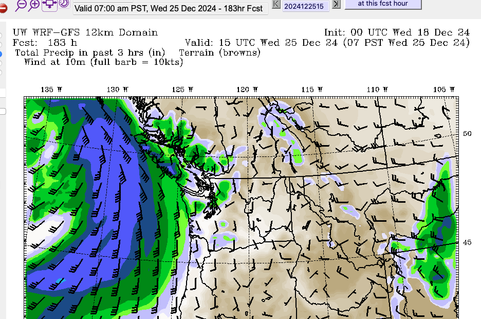
Alberniweather Banner Image of Harbour

Archive for the ‘Wind’ Category

God: One Wind and Rain Storm for the Olympics please

Saturday, February 6th, 2010

Come on, admit it. You’re secretly wishing for it aren’t you ;)
Welcome to Vancouver, Need an Umbrella? :D

UPDATE: This is getting a little more serious now. As of this morning (Monday) the GFS has increased its estimate up to 210mm Thursday through Sunday. With the largest amounts coming Friday night and Sunday morning. The probability of strong winds has also increased particularly for all of Saturday but also on Thursday night . Saturday is still 6 days away, so this forecast could still change but at this point it is pretty ugly.

On the bright side, the temperatures aren’t forecast to be above 8 degrees. So maybe, juuuuuust maybe, Cypress Bowl will get a big dump of snow right in time for the Olympics.

Or maybe they’ll still have to snowboard on the straw bales and 2 month old snow, while it pukes down sleet.

Oh I don’t envy those athletes nor the organizers one bit. They’re really not getting much of a break!

We’ll see how it pans out.

Full Disclosure: My wife, daughter and I will be at the Opening Ceremonies on Friday (nosebleeds! 5 from the top of BC Place!) and Canada vs. Slovakia womens hockey on Saturday. We’re extremely excited and I really hope the weather is OK. We’re also very thankful to my friends in Vancouver who have put us up (or are putting up with us? :) ) for 3 nights! Thanks Rod and Roz, you’re the best!!

Very Low Barometer… windy tonight

Sunday, January 17th, 2010

(Update: Did I call it? ;) Wind Warning now issued for all of Vancouver Island and Lower Mainland… look for the barometer to head towards 97kpa. The closer it gets, the stronger shot we will receive. Up to 80kph)

You might have noticed the barometer value up top is in the yellow. That generally means one thing. Wind!

The GFS model is saying we’ll get down to 98kpa tonight. We’re certainly on our way.

We should get some moderate rain tonight before the wind comes. Just 20-25 in the forecast so shouldn’t be a risk of flooding. We’re looking at about half the amount this storm than we did the past two.

The GFS windogram says we’re in for only 15knot winds. This is actually the first time I’ve used the windogram for our area, so we’ll see how accurate it is. I have a feeling it underestimates greatly as EC generally does as well.

And some of you might like to know. We got a visit on Friday from Dr. Andrew Weaver, 2007 Nobel Peace Prize winner for 2007 with the IPCC. He was here to take some pictures of our weather station as it is part of his islandweather.ca network and to install new stations on Alberni Elementary and Maquinna Elementary. My wife met him, without realizing his fame :) I was not home from work yet. Bummer!

Anyway, stay safe out there! And hey, end of January/beginning of February is still looking cool, possibility of snow in time for the Olympics? (Imagine a giant dump of snow on Vancouver on February 13! OMG hahah)

El Nino is finally coming

Thursday, January 14th, 2010

UPDATE: Flood Watch Ended for Port Alberni thanks to cooler temps/snow in mountains—But Flood Warning for Cowichan Valley issued (details here)

As Jeff Masters at WUnderground and many other weather bloggers have said… this year hasn’t been your typical El Nino year in North America. Why? Because we had an exceptionally negative Arctic Oscillation and North Atlantic Oscillation that kinked the jetstream all crazy like and allowed waves of very cold Arctic air to flow down into North America and Europe (and very warm air to flow into Alaska and Greenland).

Well… that weather pattern is breaking down now… and it looks like the jetstream will move south into a more El Nino like pattern and flow across the continent, bringing more storms to California rather than us and warmth to the Eastern US.

Before that happens though, we need to get through this weekend. We’re expecting over 100mm over the next couple days, and then probably another shot over 50mm on Sunday/Monday.

Once we hit late next week, the temperatures should cool off a bit and while we won’t be getting any large dumps of snow, it should at least calm the nerves of VANOC as the snow comes back to the local mountains.

Oh and, and speaking of the Olympics. Apparently there is a new data gathering service being set up by the NOAA flying out of Japan to coincide with the Olympics in Vancouver . Their goal is to gather weather data from the West and Central North Pacific waters where data is sparse right now.

The Pacific is literally where most of the weather comes from for North America, so this data will be fed directly into computer models and should make them more accurate in their long term forecasts not just for us, but all of North America.

The rain *is* coming… and other weather news.

Wednesday, January 6th, 2010

So it’s really been a fairly boring start to 2010 so far. Especially considering what we went last year, this year just seems downright normal! (It actually feels pretty normal to me, this is what I remember winters being like growing up).

But, do not despair last week the models were saying we’d get a whole bunch of rain starting around tomorrow and Friday, and it looks like that forecast was right. Not only does the short-medium forecast say it’s going to rain starting Friday and through until next Tuesday… but it’s going to rain quite a lot. 200mm between now and then.

Looks like there is a possibility for some wind around Saturday or Sunday, but it doesn’t look like anything major, maybe up to 40-50kph.

Weather around the world… specifically… anywhere between the Rockies and Russia, is pretty interesting right now. Central and Eastern North America are in a deep freeze. Tampa Bay, Florida set a 99 year record yesterday. They got down to -2C on the 5th… breaking the record of 0C set in 1911.

Records are falling for snowfall and temperatures everywhere from England, to Norway (Every, single City in Norway is below zero right now!), to Beijing.

Why? The Arctic Oscillation is its strongest “negative” phase since records began in 1950. This is causing the related North Atlantic Oscillation to be strongly negative as well, which affects the jetstream that keeps North East North America and most of Western Europe warm in the winter. There is a good description here of what a negative NAO does here.

Oh.. and getting back to Floria… go use the Wundermap… to see current temperatures in Florida and Alaska. It’s the same temperature in Tampa this morning as it is in Anchorage!

Happy New Year… two weeks of Wet! (and wind?)

Tuesday, December 29th, 2009

So doing my regular swipe through the forecast models today and I came across a beauty of a long range forecast.

Basically, our first few weeks of 2010 are going to be wet. And not just a little wet. If the forecast holds (and yes, that’s a big if right now) then between January 1 and January 14, we could see upwards of 400mm of rain.

That’s what the model is saying right now. Again. This could change, but it’s worth noting that there are “big” things being forecast all around North America right now. From a major New Years Eve blizzard in New England and New Brunswick, to a major cold snap afterwards across the continent… to.. yes.. our little neck of the woods. Where we have one mother of a week coming at us.

At this point it looks like there could be a good shot of wind as well with the system on the 8th-10th period. But again, it’s very far out, so too soon to say for sure.

So there’s you’re New Years heads up. Get ready for at least a little rain… and possibly… as much as we had in November. No small feat.

Port Alberni, BC – Central Vancouver Island Weather Conditions is proudly powered by WordPress
Entries (RSS) and Comments (RSS).


Valid XHTML 1.1
Valid CSS!
Credit Counseling - Arizona Landscaping - click fraud protection - Renegade Motorhomes